Wednesday, February 29, 2012

DuPont State Forest Waterfall Hike
Transylvania County, NC
Saturday, February 25th, 2012


This past weekend was Amy's Mom's 70th birthday celebration which Amy and I were hosting at our house.  We definitely had a house full!

My brother-in-law Hugh and I decided that we needed to escape the Sane craziness for a little while and head up to the mountains.  DuPont State Forest is one of my favorite places to take people who have not seen much of the area.

 It is fairly close to home, the hiking is relatively easy, and the series of waterfalls on the Little River are some of the most impressive around.  So after a nice family breakfast, Hugh and I hit the road up I-26, through Flat Rock, NC, and on to DuPont State Forest. 

We parked at the Hooker Falls / Triple Falls parking area and started out with the quick and easy quarter mile warm up hike to Hooker Falls.  It was a beautiful morning, but the intense sun was located above the waterfall and shining directly into my camera lens.  I quickly realized that this would not be a good day for waterfall photography, but it was still a beautiful day for a hike!

Hooker Falls

I settled for a few quick shots from the side of Hooker Falls, before returning to the parking area to begin our main hike!

We crossed the road, and headed out on the Triple Falls Trail.  After the initial flat section, we began the short but steep climb to the Triple Falls overlook area.  This is the best spot to view all three drops of Triple Falls from one vantage point!

Triple Falls

However, we wanted to go for a closer view.  There used to be a very steep scramble path down to the base of the middle drop of Triple Falls, but recently that path has been replaced with a very well-constructed series of wooden steps making the descent much easier.

The Middle Drop of Triple Falls

After a quick break at the base of the middle drop, we continued on towards High Falls and took the River Bend Trail to the base of this very impressive waterfall!

High Falls

The River Bend Trail ends here, but we climbed the unofficial scramble path from the Base of High Falls back up to the High Falls Trail.  We continued on and crossed the Covered Bridge just upstream from the brink of High Falls.
The DuPont Covered Bridge

From the Covered Bridge, we turned onto Conservation Road and then took the Pitch Pine Trail.  We crossed Joanna Road and then took the "Three Lakes Trail". 

The Three Lakes Trail used to be called the Lake Dense Trail which would take you past Lake Dense and then dead end at Lake Alford.  However, this trail has recently been extended to also include Lake Julia and hence the name change to the "Three Lakes Trail"

Lake Julia

The Three Lakes Trail now continues on past Lake Julia, the Lake Julia Dam, and alongside the Lake Julia Spillway before coming to an end at Conservation Road about 100 yards north of the bridge over the Lake Julia Spillway. 

The new Three Lakes Trailhead at Conservation Road

We continued South on Conservation Road towards the DuPont Barn where we turned onto The Bridal Veil Falls Trail

The DuPont Barn

The Bridal Veil Falls Trail ends at the base of Bridal Veil Falls, but I wanted to give Hugh and experience that you just can't get from the base!

So we started the climb alongside Bridal Veil Falls.  The rock incline was mostly dry making this much easier than it is during times of high water or recent rain.  We probably could have made it all the way to the upper drop, but there were some slick spots towards the end.  Just to be on the safe side, we decided to head into the woods for the final 50 yards or so.

We exited the woods right next to the upper drop of Bridal Veil Falls.  There was really no point to what I was about to do, but I led Hugh underneath and behind the waterfall!

Hugh Crossing under Bridal Veil Falls

There is a scene from the movie "The Last of the Mohicans that was filmed at this exact spot with a group of Indians doing exactly what we were doing.

We made it safely across the river and took a little break to enjoy the view from the other side. 

The Upper Drop of Bridal Veil Falls

Physically, it is possible to create some nice loop hikes using "The going behind Bridal Veil Falls method" of crossing the Little River.  However, this route also requires crossing a small section of private property.  Several years ago, my buddy Andy and I had a run-in with a Rent-a-Cop and almost got arrested while crossing over this section of private property.  Since I was not willing to take Hugh on any adventures that involve jail cells, I scrapped the loop hike idea and just planned an out and back hike.

This meant going back under Bridal Veil Falls and heading back the way we came.  I did throw in a few minor variations for the hike back.  For the return route we stuck to Conservation Road instead of the Three Lakes and Pitch Pine Trails.  We also avoided the River Bend Trail and instead elected for the more distant view of High Falls.

High Falls

One final little side path we took was to the base of the Lower Drop of Triple Falls, where we took our final break of the day before heading back to my vehicle!

Me at the Lower Drop of Triple Falls

For the drive back home, I decided to show Hugh the more scenic route past Caesars Head, SC where we made a quick stop to check out the views!

Hugh at the Caesars Head Overlook

It was a beautiful day for a hike and it was great to give Hugh a little taste of what the Carolina Mountains have to offer!

The bright sun did not make for optimal waterfall photography, but that didn't stop me from trying!  The complete set of photos is posted here:


Tuesday, February 21, 2012

Headforemost Creek
Waterfall Wandering Bushwhacking Adventure
Mountain Bridge Wilderness
Greenville County, SC
Saturday, February 18th, 2012

Me at Headforemost Falls

For years I have been aware of waterfalls on Headforemost Creek, and for years I have been wanting to find them.  Unfortunately there are no trails that lead to these waterfalls.

Both Andy and I have spent some time studying topo maps and figured that the easiest way would be to come up from downstream.  Unfortunately this would  require trespassing across heavily posted private property which is out of the question.

Two years ago, Andy and I attempted a different approach by coming downstream from the Hospital Rock Trail.   During that trip, we did find a couple of small waterfalls and cascades upstream from the main drops of Headforemost Creek, but as we got to the brink of the uppermost major drop we were running out of time and energy to be able to find a safe route down to the base.

This year we would try a different approach which hopefully would not be too difficult and would keep also keep us off private property.

Andy, Boone, and I started at the Falls Creek Falls Trailhead just outside of Jones Gap State Park, SC.  One nice thing about this trailhead is we saved that pesky $2.00/person SC State Park Entrance Fee.

The trail to Falls Creek Falls is about 1.2 miles, but it is extremely steep and eroded  in places.  I learned that hard way many years ago that this trail is NOT Amy approved!  (Note:  Amy was able to make it to the waterfall on that trip, but she was not a happy camper!)

Falls Creek Falls is one of the most spectacular waterfalls in South Carolina.  Unfortunately, I have never been able to take a photo that is able to really show the true magnitude and awesomeness of this waterfall.  Today was no exception and  the bright sunlight shining directly on the waterfall made matters even worse.

Falls Creek Falls

We spent a few minutes trying to take some photos, but decided that the light would be better later in the day when we would pass by again.  So we continued on the Falls Creek Falls Trail.

Andy Crossing Falls Creek at the base of Falls Creek Falls

The steep climb of the trail continued.  Our plan was to leave the trail and start Bushwhacking to the west towards Headforemost Creek.  We really didn't know where the best place to start our Bushwhack would be, but just as the trail made a turn towards the north, I suggested to Andy that this looked like a good place to start bushwhacking.

Andy was originally thinking that we should head higher up, but we ultimately went with my suggestion which I think turned out to be the wiser choice.  The bushwhack started off relatively easy through a fairly open forest.

We maintained a relatively constant elevation as we made our way towards the west through some huge boulder fields.  As far as bushwhacking goes, this was pretty mild, but still much more challenging and time consuming than  typical trail hiking.

Bushwhacking by some impressive Boulders

Vegetation thickened in spots where a few small streams and springs flow down the mountain and there were a few gullies to navigate through, but for the most part we made it to Headforemost Creek without any problems.  The Bushwhack of approximately one mile took about an hour and a half.

We arrived at a nice little waterfall and series of cascades where we took a photography break.
Andy and Boone by some cascades on Headforemost Creek

This was a nice little cascade, but there appeared to be more impressive drops both upstream and downstream.  We decided to head upstream first!

This proved to be the most difficult part of the day as we made our way uphill through Rhododendron, Briars, and Boulders.  We eventually arrived at the base the major upper drop!  I am pretty sure that this is the same drop where last year we made it to the brink, but today we achieved our goal of making it to the base.
The Uppermost Main Drop of Headforemost Falls

Unfortunately, while an impressive sight, this waterfall is not very photogenic and not really worth the effort it took to get there.  We certainly hoped we would find some better stuff downstream.

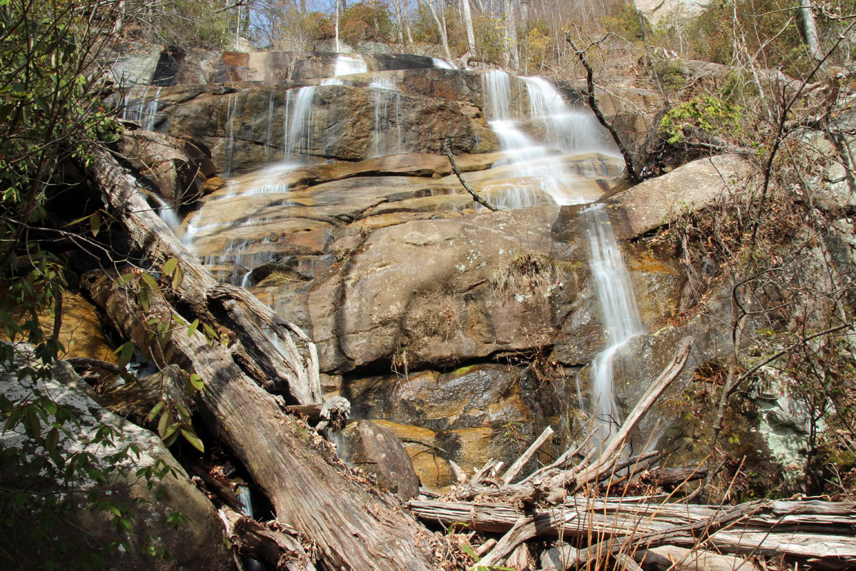
The descent was made a bit easier by our decision to head further away from the creek where the vegetation thinned out a bit, but it was still a very steep descent!  We eventually worked our way back to the creek and were rewarded as we approached the main Lower Drop of Headforemost Falls.

Headforemost Falls

We spent a good bit of time photographing this one from many different angles and vantage points before deciding to head on.

We continued downstream where we picked up an old forest road and soon spotted another waterfall down the steep bank, which we went to check out!

While definitely not as high or as impressive as some of the other drops along Headforemost Creek, this little waterfall was my favorite from a photography standpoint!

Small Waterfall downstream on Headforemost Creek

We continued on the well maintained forest road, but we were pretty certain that if we continued on, we would eventually end up on private property, so we turned off the main road onto another obvious, but not as well maintained old road.

Unfortunately, this route fizzled out and we were forced back into Bushwhacking mode through some not so hospitable terrain!  This route was definitely much more difficult and time consuming as the route we used to approach Headforemost Creek earlier in the day.  At one point we passed by the remains of an old Moonshine Still.

Remains of an old Moonshine Still

We eventually made it back to some familiar territory and from there we pretty much followed our original path back to the Falls Creek Falls Trail. 

The sky had clouded up quite a bit since earlier in the day, making  photography conditions of Falls Creek Falls much better.  However the wind had also picked up increasing the amount of waterfall spray making it difficult to keep the water droplets off the lens.

Falls Creek Falls

We had earlier discussed doing some further exploring of Falls Creek and Little Falls Creek, but that would have to wait for another day as we were running out of both time and energy!

Overall, it was a very enjoyable day and both Andy and I were pleased to have been able to achieve our goal of finally making it to Headforemost Falls!

The complete set of photos from our Adventure is posted here:
http://outdoors.webshots.com/album/582364127mbQITQ

Monday, February 20, 2012

Dog Tired!

Here is a shot from Saturday's Adventure of one of my hiking buddies after a tough bushwhack!

Boone after a tough Bushwhack!

Sunday, February 19, 2012

More New Waterfalls

Andy, Boone, and I had another successful Waterfall Wandering Bushwhacking Adventure Yesterday!  Here are some photos of the new waterfalls we visited.

Andy


Self Portrait


Sunday, February 12, 2012

CMLC Bearwallow Mountain Hike
Henderson County, NC
Saturday, February 11th, 2012


After our hike to Rainbow Falls, Andy and I continued up the road to Gerton, NC to meet the CMLC (Carolina Mountain Land Conservancy) group at the Florence Nature Preserve Trailhead.  This would be the end point of our hike.  I was surprised to see some light snow flurries in the air!  On top of that, the weather seemed significantly cooler than I was expecting!  And it would only get worse!

From there the group gathered together and formed a shuttle to the starting point along Bearwallow Mountain Road.  The snow got heavier as we drove up the mountain and the ground was covered with a light dusting.  Compared to the warm winter we have been having, this was was downright frigid!  And the gusting wind made things much worse!

The group gathering at the trailhead in blustering wind and snow

I have hiked to the summit of Bearwallow Mountain several times in the past, but it has always been along a wide track access road.  Since my last hike, a new trail had been constructed which avoids the road walk and would make for a much more interesting hike.  Despite the cold and wind, I was excited to check out the new trail. 

This is a very well constructed trail, with gradual switchbacks making the climb to Bearwallow Mountain surprisingly easy.  The only challenge was dealing with the cold, wind, and snow!

The group hiking the new trail up Bearwallow Mountain

I had checked the weather forecast beforehand to prepare for the hike and saw the high for the day would be 48 degrees in Chimney Rock Village. However, I failed to take into consideration that the starting point of the hike was a good 2,500 feet of elevation above Chimney Rock Village and parts of the hike would take us to elevations over 4,000 feet above sea level.

This was much colder than I was prepared for!  Less than 5 minutes into the hike, the water tube on my Cambelback had frozen solid.  Temperatures were well below freezing and with 40 mph gusts, the wind chill factor was probably close to zero!  I was extremely grateful that I though to bring along my goofy cold weather hat and a pair gloves!  But some thicker socks and a warmer pair of pants would have been nice!

But the group of about (25) hikers pressed on and made it to the summit of Bearwallow Mountain without any issues!
Approaching the summit of Bearwallow Mountain

On a clear day, the summit of Bearwallow Mountain offers some spectacular views!  Today the views were limited, but we were treated to a spectacular display of winter fury!  We took a short break, but due to the cold and the wind we didn't linger at the summit for very long!


A touch of Rime Ice on the trees at the summit of Bearwallow Mountain

Since the rest of the hike would be along some very rugged terrain, part of the group elected to turn back while (14) of us continued on.  We descended down the east side of Bearwallow Mountain towards the meadows at Bearwallow Gap.

Bearwallow Gap

A mountain spring forms several watering holes in the meadow between Bearwallow and Little Bearwallow Mountains.  Apparently bears wallow in these watering holes which is how the mountains got their names! 


The Bear Wallowing Water Hole at Bearwallow Mountain Gap

We continued on at a good pace up to the summit of Little Bearwallow Mountain and my body had warmed up to the point that I no longer felt cold!
Hiking up Little Bearwallow Mountain

We continued on the Little Bearwallow Mountain Trail and where we were treated to an extensive and impressive display of icicles.

Icicles along the Little Bearwallow Mountain Trail

Our plan was to take our main break of the day at Wildcat Rock, so we took the short side trail that leads to this impressive rock outcrop.


The side trail to Wildcat Rock

Wildcat Rock offers up some really nice views, but it also offered up full exposure to the blustering wind!  I took a few quick photos, but i didn't feel comfortable working my way out to the fully exposed rocks which offer the best views!  Covered with snow and ice, and with wind gusts strong enough to blow a human off a mountain, it did not seem like a good idea!

view from Wildcat Rock

While the plan was to break for lunch on Wildcat rock, most of the group elected to break down below which was more sheltered from the wind.  My camelback water tube was still frozen solid rendering it useless.  I was glad a tossed in a couple of extra water bottles which even inside my pack had started to form ice crystals, but were still drinkable!

We took a much quicker than planned break as the group was eager to get moving again!  It is best not to stop for very long in this type of weather! 
 
We continued to the east on the Cliffs Trail.  With its northern exposure may parts of this trail never see sunlight during the winter.  As a result, we were treated to some more very impressive displays of icicles which form as water seeps down the cliffs as freezes!
 
Hiking along the Cliffs Trail
 
This trail is well blazed and easy to follow, but it is very rugged!  It is the type of trail that you are not likely to travel much more than a mile in an hour.  Fortunately, the direction we were heading is mostly downhill which would take us out of the worst of the wind and down to slightly warmer temperatures.
 
We stopped for another short break to check out a wet weather waterfall at Little Bearwallow Cliff.  Today this was very unimpressive!  This one would have to be visited immediately after a significant rain shower to be worthwhile!
 
An impressive cliff face with a less than impressive wet weather waterfall

The hiking got much easier from here as the trails got closer to civilization making trail maintenance access much easier.  Also, the terrain started to level out as we approached the creek alongside US74A.  There are several nice cascades along this stretch of trail which would make for some good photo opportunities.  Since I elected not to tote along the tri-pod, today I would just have to settle for a quick balance the camera on a rock type of shot! 

Cascade Falls

At 2,500 feet lower than at the high point of our hike, the temperatures were much more bearable near the end of the hike.  However the wind was still gusting and as we were getting towards the end of the trail we heard and saw a large tree come crashing down about 100 yards away from us!

The hike ended with a leisurely stroll through an old Apple Orchard just across the road from the Florence Nature Preserve Trailhead where our vehicles were waiting for us!

The end of the hike through an old Apple Orchard

This was a great hike!  Much more extreme than the typical CMLC hike!  Fortunately the entire group managed to escape without any significant falls or injuries!  Thanks to Peter and Chet for leading this awesome hike! 

Saturday, February 11, 2012

Rainbow Falls
Rutherford County, NC
Saturday, February 11th, 2012

Me at Rainbow Falls

There are several "Rainbow Falls" in the Carolinas, but one that I had yet to visit has been the one in Rutherford County, NC.  I have caught some distant views of it on occasion from way across the gorge at Chimney Rock Park, but I have never see it up close. 

Andy and I had signed up for the CMLC (Carolina Mountain Land Conservancy) hike to Bearwallow Mountain.  However, that hike didn't start until 10:30am which meant we had some time in the morning to do a little exploring.

Thanks to the efforts of groups like the CMLC, the Rainbow Falls property is now owned by the State of North Carolina.  However, official public access has still not been established.  Fortunately Andy and I received a tip on how we could access Rainbow Falls.

The morning started with an unusual event!  Andy actually arrived at our meet-up spot at the Lake Lure Marina a few minutes before me!  We combined into my truck and continued up through Chimney Rock and turned into the "Reserve at Rainbow Falls" development.

Years ago, the side of the mountain below Rainbow Falls was scarred when a developer put in a road and tried to sell about a dozen $400,000 lots.  Years later, not a single lot has been sold, but the road is still there and would lead us to an access point to Rainbow Falls.

Yes, technically we started out on private property, but if anyone asks we were looking to invest in a mountain side piece of property.  Lot #6 looked like a good one to check out, so we parked my truck, grabbed our cameras and tripods, and walked up the hill to the far back corner of the lot where low and behold we ran into the official boundary line of the new State Park.  Maybe we could get a better overview of lot #6 if we continued higher up the mountain?

We could catch a few glimpses of Rainbow Falls through the trees up ahead, but from here the more impressive view was an across the gorge view of Hickory Nut Falls.

Zoomed in distant view of Hickory Nut Falls

Officially inside public property we followed an obvious trail which switchbacks up the mountain gaining about 400-feet of elevation.  We were surprised to come across a small A-Frame cabin, obvious signs that this land was once private property.  We did receive confirmation later in the day that the cabin is now owned by the State of North Carolina and officially inside the state park boundary.

A-Frame Cabin near the base of Rainbow Falls

We continued on a short distance past the cabin towards Rainbow Falls.  I was glad I convinced Andy to meet a half hour earlier than planned.  While this wasn't a long hike by any means, we would have been pushed for time if we went with our original meet-up time.  Plus a half hour later and the sun would have made photography much more difficult.

The sun creeping over the ridge making photography from this angle difficult

We spent about a half hour photographing Rainbow Falls from various vantage points before heading back down to my vehicle.

Rainbow Falls


Rainbow Falls


Rainbow Falls


On the hike down, we rain into a group of about 12 hikers.  Apparently they were interested in checking out Lot #6 as well.  In fact, I think I will have to head back and check out Lot #6 again during the spring.  We noticed a few trillium starting to come up by the base of the falls!

Meet Zoey

 Meet Zoey! Amy and I just adopted this beautiful girl!