The 2019 Fork Creek Overarching Epicity Tour
Still House Falls and Elmo Falls
Pisgah National Forest
Transylvania County, NC
Friday, June 21st, 2019
Group Photo at Elmo Falls
Photo by Ryan Mallon
I celebrated this years Summer Solstice by taking Friday off from work to join in on the 2019 Fork Creek Summer Solstice Overarching Epicity Tour! While these waterfalls are all located on public land within the boundaries of the Pisgah National Forest, access and parking can be questionable.
Found on my windshield at the end of the hike.
My vehicle was parked at the northern intersection of Slick Fisher Road and Hwy 281.
Therefore I will not be posting my GPS track from this adventure!
Joining in on this adventure would be Thomas Mabry (Badger), Kitty Myers (Rock Sprite), Scott Burns (The Professor), Everette Robinson (Everest Denali), Joey Cagle, Ryan Mallon (Mountain Cat), and Eliza Stone-Crib.
Eight Went In
L to R: Thomas, Kitty, Scott, Joey, Eliza, Ryan, Me, Everette
L to R: Thomas, Kitty, Scott, Joey, Eliza, Ryan, Me, Everette
(From the Badger Selfie Collection)
First on the agenda was Laceration Falls. I was not overly impressed by the waterfall itself. However, there were a few nice blooms to focus on and Badger's re-enactment of how Laceration Falls got it's name was very impressive!
Some nice blooms at Laceration Falls
Badger Re-enactment of how Laceration Falls got it's name
Next up would be Devil's Canyon! Despite the rugged terrain and a valiant attempt to keep us away by a large group of angry Yellow Jackets, we made it to the Devil's Canyon. Definitely worthy of a Badger Thumbs Up! I concur!
Devil's Canyon Falls gets a Thumbs Up by the Badger!
Badger gives a Thumbs Up to the Mountain Cat Handstand at Devil's Canyon Falls
Badger and Mountain Cat at Devil's Canyon Falls
After Devil's Canyon we continued on to Still House Falls. Again, I am not going to post my GPS track, but you can find information about the waterfalls below on pages 311-313 of Kevin Adam's North Carolina Waterfall Bible (3rd Edition).
Still House Falls is a beauty! I can't believe I hadn't made it here until now! And since the lighting was not good for waterfall photography I will definitely be back!
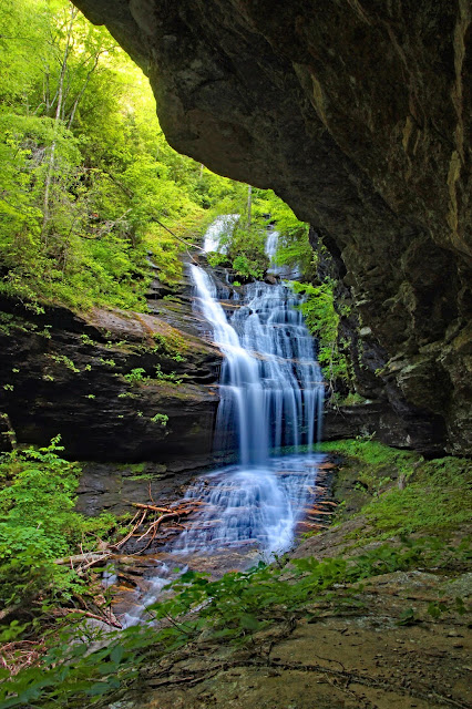
Still House Falls
Still House Falls Selfie with Eliza, Thomas, and Scott
Group Photo (except for Kitty) at Still House Falls
L to R: Scott, Joey, Thomas, Everette, Ryan, Eliza, Me
A Mountain Cat Flip at Still House Falls
The Professor and the Badger at Still House Falls
Eliza working her way down from Still House Falls
After Stillhouse Falls we continued downstream hitting several additional smaller waterfalls and cascades along the way!
Everette making has way down Lower Still House Falls
Hidden Falls
Kitty and Scott at Cleft Falls
Badger Perch at Emily's Cascade
Emily's Cascade
Eventually we made it to "Staging Rock" near the top of Elmo Falls. This is the spot where you have to decide how the heck to get down to the base. My gut was telling me that river right looked like the better way to go. However, the group ultimately decided to head down river left.
Nice cascades at the top of Elmo Falls
Kitty, Joey, Eliza, and Scott at the Staging rock near the top of Elmo Falls
I can't say if river right would have been any better, but I can say that river left took us almost 3 hours to get from the top of Elmo Falls to the base. This included included another Yellow Jacket attack and about a 2 hour detour to advance approximately 15 feet (not an exaggeration)!
Eliza utilizing the Butt Slide Bushwhacking Technique
Kitty checking out some cool rocks!
The Professor descending down the Mountain Cat Crevice
Setting sights on Elmo Falls made it all worthwhile! This one is truly spectacular!
Elmo Falls
Elmo Falls
Kitty and Scott at Elmo Falls
Kitty Leading the way to the Ledge of Legends
Badger Group Selfie at Elmo Falls
L to R: Thomas, Me, Kitty, Scott, Joey, Everette, Eliza, Ryan
Mountain Cat at Elmo Falls
Everest Denali photographing Elmo Falls
Say Hi to the Professor at Elmo Falls
Eliza and Ryan at Elmo Falls
After Elmo Falls, we still had about a mile of creek walking downstream to our vehicles. My plan was to drive down to Lake Keowee after the hike to join some of my other Team Waterfall Friens (Darrin, Bob, and Elliott) for an evening of camping. I had hoped to make it there in time for sunset, so Scott and I picked up the pace a bit and surged ahead of the rest of the group!
Unfortunately, I just missed the Lake Keowee sunset, but there was still a nice sky and a little swim in the lake felt awesome after the epic adventures earlier in the day!
Just after sunset at Lake Keowee
Bob, Darrin, and I had a very enjoyable evening hanging out at the lake.
Since there was a 0% chance of rain, I didn't bother to take the time to properly stake and tie down my tent and rain fly. Darrin also elected not to set up his rain fly.
Shortly before 2:00am the wind really picked up and blew my inadequately secured rain fly off. I quickly checked the radar, and saw the 0% chance of rain was now up to 100%. While trying to re-secure my rain fly, the wind caught it just right and my tent lifted up about 15 feet into the air (possibly an exaggeration).
Plan B: I collapsed the entire tent, wadded everything up into a ball, and climbed up the hillside to my truck. This is what the radar looked like once I was safely inside my truck for the rest of the evening.
0% Chance of rain for the evening?
Darrin and Elliott also ended up spending most of the night in their respective vehicles! But we all made it through safe, alive, and ready for the next camping adventure!
We enjoyed a peaceful and relaxing morning on the lake!
After the Storm! Saturday Morning Sky above Lake Keowee
Jet Ski Selfie
Elliott and Bob hanging out at the Lake
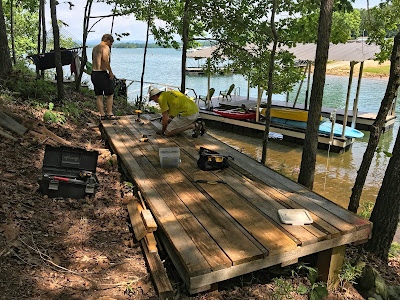
Elliott and I decided to stick around and help Bob finish up a little project he was working on. A deck / tent platform constructed entirely out of scrap wood!
Our Saturday Morning Project - Made entirely out of scrap wood
This was an awesome way to spend the Summer Solstice!
My complete set of photos is posted here:
https://www.flickr.com/photos/8146392@N05/albums/72157709262579473


