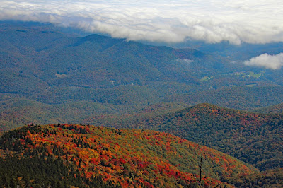
The Black Mountain Crest Trail
(aka The Deep Gap Trail)
Mount Mitchell State Park
Yancey County, NC
Saturday, October 15th, 2016
view from the Black Mountain Crest Trail
This was the weekend of the annual SSPBDT Mancation Camping Weekend. Since most of my SSPBDT friends are non-hikers, I came prepared to do a solo hike on Saturday. I almost convinced one of my buddies to join me, but some Apple Crown the night before did him in!
So for my solo hike, I decided on the Black Mountain Crest Trail from Mount Mitchell and back!
It is about an hour drive from Camp Buff to Mount Mitchell, but I made a few stops along the Blue Ridge Parkway to check out some of the overlooks.
view from the Blue Ridge Parkway
Once I arrived at Mount Mitchell state park, I started out with the short climb up to the Summit of Mount Mitchell. I have been up to the summit about a half dozen times in the past and this was the first time I actually had clear views!
at the Summit of Mount Mitchell
view from the Summit of Mount Mitchell
view from the Summit of Mount Mitchell
I descended down from the summit and continued on to the Black Mountain Crest Trailhead.
This would be an out and back hike, so I would play it by ear as to how far I went before turning back. I ended up going to the viewpoint just beyond Potato Hill which is about 3.5 miles (one way).
From Mount Mitchell to Mount Craig the trails were loaded with people, but beyond Mount Craig I only ran across a few other hikers, so most of the hike was in solitude.
Here are a few photos from my hike:
view from the Black Mountain Crest Trail
view from the Black Mountain Crest Trail
view from the Black Mountain Crest Trail
Panorama view from the Black Mountain Crest Trail
view from the Black Mountain Crest Trail
view from the Black Mountain Crest Trail
When I finished up the hike the parking area was 100% full! Even though I don't like crowds, I decided to climb up to the top of Mount Mitchell to experience the madness first hand! Definitely crowded, but I did get a few of good shots up there which made it worth fighting the crowds!
at the Summit of Mount Mitchell
view from the Summit of Mount Mitchell
The Mount Mitchell Summit
at the Summit of Mount Mitchell
Overall, including both climbs up to the Mount Mitchell summit, the total distance was about 7.0 miles. Even though you never climb more the 300-400 feet at one time, the total cumulative elevation gain was about 1,700 feet.
GPS Track
The worst part about the entire day was dealing with the line of cars driving 10mph down the mountain and along the Blue Ridge Parkway. It did give me some excuses to stop and check out some of the foggy views on the way back to my SSPBDT Mancation Buddies at Camp Buff!
Along the Blue Ridge Parkway
Along the Blue Ridge Parkway
Cool Tree along the Blue Ridge Parkway
The complete set of photos from my hike is posted here:
https://www.flickr.com/photos/8146392@N05/albums/72157671900018274


No comments:
Post a Comment