Pisgah National Forest Waterfall Adventure
Including a New Waterfall Discovery!
Transylvania County, NC
John Rock, Saxifrage Falls, King Creek Falls, Fawn Branch Falls,
Cedar Rock Creek Falls, Lemon Falls, and Eastatoe Falls
Saturday, February 4th, 2017
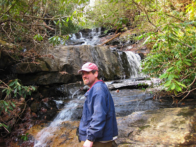
Me and Mark at Fawn Branch Falls
We believe we are the first explorers to document the existence of this one!
Since my last few weekends involved a whole lotta bushwhacking I decided to stick to mostly trail hiking for today's plan. I plotted out a route that would include mostly familiar territory, but also add in a couple of waterfalls that neither Mark nor I have ever been to.
On page 187 of Kevin Adam's "North Carolina Waterfalls" (3rd Edition), he has a short write-up for Saxifrage Falls and King Creek Falls. These would be our primary goal for the day!
It was a chilly 22 degrees when we started out from the Pisgah Fish Hatchery just north of Brevard, NC. Originally, I had planned on skipping John Rock, but instead we decided that a little extra climb to start out the hike would help get the blood moving and warm us up a bit!
View of Looking Glass Rock from John Rock
Mark Photographing the View from John Rock
The John Rock Death Slide!
From John Rock, we continued on to Cat Gap. Most trail maps show Cat Gap to be a 4-way intersection. However there is a 5th trail that heads off to the South East. We would take this over towards King Creek. While the trail is not signed or blazed, it is very obvious and easy to follow.
Me along the trail
The trail soon crosses over FR475C and continues on down the river left side of King Creek. Saxifrage Falls is approximately a mile downstream from FR475C. A short but steep scramble took us to the base of this pretty little waterfall.
Mark at Saxifrage Falls
Ice at Saxifrage Falls
Saxifrage Falls
A short distance downstream from Saxifrage Falls is King Creek Falls. Again this one requires a steep scramble to get down to the base.
Me and Mark at King Creek Falls
This one is pretty neat, but not very photogenic, especially with the amount of deadfall cluttering the base.
Ice covered deadfall at King Creek Falls
My favorite feature of this waterfall is the cool cave right at the base of the falls.
Looking out at King Creek Falls from inside a cool cave
Even though I had planned mostly trail hiking, I just had to add a little something extra in order to live up to my Bushwhack Jack moniker!
Fawn Branch joins King Creek a short distance downstream from King Creek Falls. I just couldn't help but notice on the topo map that Fawn Branch follows pretty much the same elevation drop as King Creek! So we bushwhacked down King Creek to it's confluence with Fawn Branch.
I was concerned that Fawn Branch would be just a small trickle of stream. We were pleasantly surprised to find almost as much water as King Creek! Heading up Fawn Branch is no easy task, especially considering that we were both trying to keep our feet dry.
Most of Fawn Branch is just a long rock slide. And those rocks are slick! Especially the ones in the shade which were still covered with a layer of ice.
Lower Fawn Branch Falls
Eventually we got to a drop significant and pretty enough to pull out the camera and declare this new discovery as Fawn Branch Falls!
Mark at Fawn Branch Falls
Me at Fawn Branch Falls (photo by Mark)
Fawn Branch Falls
We pretty much returned back to Cat Cap the way we came and took a short break there to discuss our options
GPS Track from our hike
We chose a return route that would take us past a couple of waterfalls on Cedar Rock Creek.
Campsite Falls (aka Upper Cedar Rock Falls) is nothing special but well worth the quick stop.
Campsite Falls (aka Upper Cedar Rock Creek Falls)
Just downstream from the campsite is Cedar Rock Creek Falls which requires a bit more effort, but still easily accessible for most people. This one has always been one of my favorite smaller waterfalls.
Cedar Rock Creek Falls
Me and Mark at Cedar Rock Creek Falls
Cedar Rock Creek Falls
Cedar Rock Creek Falls
Mark and I both are fans of early starts and we both move at a pretty good pace leaving plenty of daylight left at the end of our hike. We decided to add in a couple of roadside waterfalls off of NC215 just north of Rosman, NC.
First up was Lemon Falls (page 231 of Kevin Adam's NC Waterfall Bible 3rd Edition)
Lemon Falls
Lemon Falls
Lower Lemon Falls
Our only failure of the day came next. On page 229 Kevin lists Big Bearwallow Falls and inlcudes a beautiful photo of this one. I am 99% certain we were at the right spot, but I could not figure out how to capture this one. I believe there are a few recent trees fallen in front of and on top of this waterfall. I did not even bother to pull out the camera for this one.
But we did not let the one failure ruin an otherwise perfect day. Instead we stopped for a beer!

Since we would be driving right past, we decided to hit one last waterfall on the way back home. Every time I pick up Kevin Adam's latest edition, I just can't help admiring this beauty! The always awesome Eastatoe Falls!
Eastatoe Falls
Eastatoe Falls
Mark and Me at Eastatoe Falls
This was another excellent day of waterfall wandering!
The complete set of photos is posted here:
https://www.flickr.com/photos/8146392@N05/albums/72157679931614366


No comments:
Post a Comment