Horsepasture River Adventure to
Windy Falls and Beyond
Windy Falls, Terrifying Falls, Wolverine Falls,
Hen Tail Falls, and Rooster Tail Falls
Transylvania County, NC
Saturday, July 8th, 2017
with Scott (the Professor), Pamela, Wendy, and The other Jack

Group Photo at Rooster Tail Falls
L to R: Me, Scott, Pamela, Wendy, the other Jack
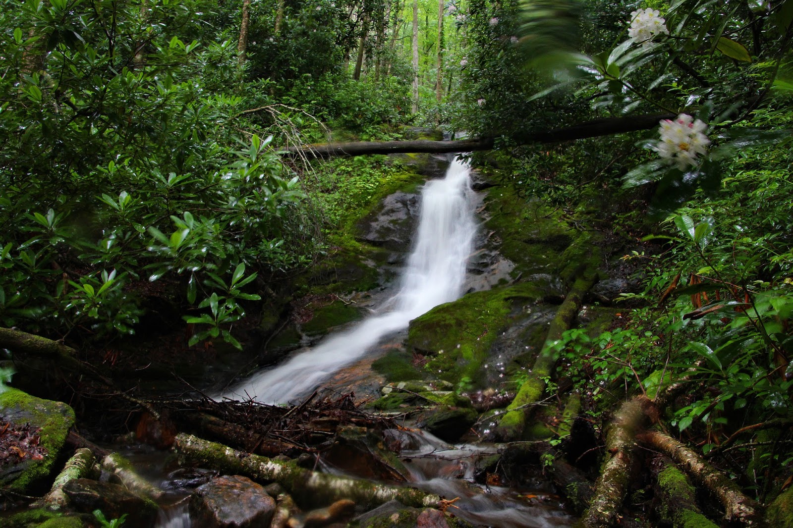
Windy Falls on the Horsepasture River has kind of a cult following amongst the waterfall community. I made my first visit back in 2015, and was looking forward to a return visit.
Joining me on this adventure would be Scott (The Professor), his girlfriend Pamela, Wendy, and "the other Jack". I have been Facebook friends with Jack Buchanan for several years, but this would be the first time the two Jacks would meet up in person! This would also be my first time hiking with Wendy and Pamela!

My hiking partners for the day
Jack Buchanan, Scott (the Professor), Pamela, and Wendy
Disclaimer: Windy Falls should only be attempted by those experienced with off trail bushwhacking, creek walking, rock scrambling, rope climbing, etc! Therefore, I am not going to post any directions or GPS tracks. Even if you are experienced with this type of adventure, first time visitors should make sure they go with a group where at least one person has been here before an knows they best and safest ways to go! Under no circumstances should this be attempted solo, during times of very heavy flow, or in the rain!
From the Parking area at Gorges State Park it is a little over a mile and about 700ft of elevation descent down to the Horsepasture River. We arrived at the River at a nice campsite next to a small waterfall that I like to call Campsite Falls. There is also a great swimming hole here which we decided to save for the end of the day. This makes for a great spot to clean up and cool off after a long day of bushwhacking!
A short distance downstream are the upper drops of Windy Falls.

Scott and Jack heading towards the top of Windy Falls

Scott and Jack at the top of the main drop of Windy Falls
There is no easy way to get to the base of Windy Falls. Most potential routes could easily lead to death. Fortunately, there is a relatively safe way down!
We headed back into the woods where we picked up some scramble paths away from danger. There are still a few areas where ropes are very helpful!

Pamela using a rope to descend down a tricky section of "trail"
We arrived at a nice rock face alongside the main drop. From here a rope is essential if you want to get to the base alive!

Jack rigging up the rope

Pamela showing us the ropes
The keyhole is a small opening just large enough for an average size human to fit through. If you can make it through the keyhole, you can avoid the scariest part of the final descent! At just a hair over 6 feet and about 195 pounds, I am about the maximum size for the keyhole. We also made things much easier and safer by lowering our gear down with the rope, so we could all make the climb down unencumbered.

The professor descending down the final climb below the keyhole.
Note: the little bit of light near the top right of this photo is the keyhole opening
From the bottom of the keyhole route you can either jump in the awesome swimming hole at the base of Windy Falls, or stay a little dryer and head for the cave route.

Wendy and Pamela heading through the cave to the base of Windy Falls
Once through the cave its an easy knee deep wade to the rocks which offer a great view of Windy Falls!

Windy Falls

Jack at Windy Falls

The Professor gives Windy Falls a well deserved Two Thumbs Up!

Wendy at Windy
After a nice break at Windy Falls, we decided to continue our journey downstream. Jack's route of choice required us to cross the Horsepasture River at the base of Windy Falls. A good bit of teamwork was used to keep all our gear dry and prevent any of us from going on an unplanned swim! The water currents here are much stronger than they appear!

Crossing the Horsepasture River at the base of Windy Falls

Windy Falls from the other side of the River
The next significant drop is Terrifying! Terrifying Falls that is! The waterfall itself is not really Terrifying, but the journey to get to it most definitely is! Rumor has it that on a previous trip, The Badger (Thomas Mabry) was almost swept away to his death in an attempt to get to the base of Terrifying Falls!

Terrifying Falls

Rhododendron Bloom at Terrifying Falls
To get here requires either a leap of faith from a slippery slope, or a traverse through a channel with surprisingly swift currents!

Wendy Downstream from Terrifying Falls
That channel of water on the left side of this photo is surprisingly difficult to get across!
From there we continued downstream. There are really no easy sections of this journey!

Scott gives Pamela a helping hand

Continuing downstream along the Horsepasture River
Next up is a multi-tiered cascade that Jack calls Wolverine Falls!

Wolverine Falls

Pamela and Wendy at Wolverine Falls
Technically the river is split at this point and we were on an island. The two channels join back together at the base of Rooster Tail Falls. But first we would check out the smaller (River Left) channel which contains another waterfall called Hen Tail Falls.

Upper Hen Tail Falls
It was a short but brutal bushwhack to get to the Lower Drop of Hen Tail Falls. Fortunately this one has a nice swimming hole at the base which was very refreshing!

Lower Hen Tail Falls

Pamela and Scott swimming at the base of Lower Hen Tail Falls
Can you spot the heart above the two Lovebirds?
An even better swimming hole can be found at the base of Rooster Tail Falls!

Rooster Tail Falls

Wendy at Rooster Tail Falls
My photos do not really give a good sense of scale to this one. So here is one of Wendy's shots of me swimming at the base!

Swimming at the base of Rooster Tail Falls
Up until this point it had been a bright and sunny day. Not really optimal for waterfall photography, but essential to keeping the rocks dry for this type of adventure! I was pleased to get a bit of cloud cover for a few long exposure photos of Rooster Tail Falls!

Rooster Tail Falls
Unfortunately, along with the clouds came some Thunder Booms! This is definitely not a place you want to be during a rainstorm. If the skies did open up, we did not want to get caught in a flash flood or have to traverse across any wet sloping rocks. Rather than head back the way we came, we decided the safest course of action wood be to head off into the woods and bushwhack upstream.
The rains definitely did come, making our decision to bushwhack a very wise choice. We rejoined the river just downstream from Windy Falls. There was one slick section we had to get across where I lost my footing, almost lost my hiking pole, and came very close to going for an unintended swim!

Windy Falls from Downstream
We all made it safely across the tricky section and took the opportunity to photograph Windy Falls in better light than earlier. The only challenge was fighting off the raindrops.

Windy Falls
In a matter of seconds, the light rain turned into a torrential downpour, so I quickly packed my camera away and we continued on to our next challenge.
Here is Jack Buchanan's description of our climb back up from Windy Falls:
"Y'all let me tell you why it's good to hike with amazing friends and hikers. We were at Windy Falls when the sky opened up and it poured for a long time. Knowing we had to get back up and through the keyhole we just went for it! Scott Burns went up first and hauled up the soaked back packs by rope( those aren't light as anyone who hiked in the rain can tell you!) Got them as far as the keyhole then had to put them through the keyhole one by one.
Wendy went second and was nearly blinded by the pouring rain getting in and on her contacts. She got safely through. Remember this was Pamela's first time here so she went next through the rain(and I'm talking it was like someone was up there throwing buckets of water through the keyhole. Please know this isn't easy in perfect conditions! She made it through like a champ! Jack Thyen went next and carried up everyone who used ones hiking poles. It was s team effort! No one freaked out and no one panicked! We were all smiles throughout the day and stayed that way through this! It made for a truly epic adventure!"
The worst of the danger was past us, since we would stay far away from the open rock faces above Windy Falls on the hike out! We were all a wet and muddy mess! Fortunately the swimming hole I mentioned near the beginning of this post was waiting for us at the base of Campsite Falls! This offered the perfect place to cool off an clean up before final climb back to the parking area.

Wendy at Campsite Falls

Wendy, Jack, Scott, and Pamela by the great swimming hole at Campsite Falls
This was an awesome adventure and an overall perfect day! It was great to finally meet "the other Jack", and really appreciated him leading us further down the Horsepasture than I have ever been! While I have briefly met Wendy and a Team Waterfall Social Gathering, it was a pleasure to finally get to hike with her!
It is always a treat to be able to hook up with Scott for a hike and today was a double treat because I finally got a chance to meet his girlfriend Pamela, who is an absolute sweetheart!
The complete set of photos from our Horsepasture River Adventure is posted here:
https://www.flickr.com/photos/8146392@N05/albums/72157683329304214