Sunday, March 31, 2013

Mountain Bridge Passage Hike

Mountain Bridge Passage Hike
Mountain Bridge Wilderness, SC
Saturday, March 30th, 2013

A few years ago my buddy Darrin "Adopted" the Mountain Bridge Passage Trail.  This means he volunteers his time to help maintain the trail.  I decided to join Darrin, his son Evan, his friend Bob, and Bob's boys for a trail maintenance hike.

 Hike Route

I knew this would be a slow paced hike, which would give me an opportunity to photograph what I hoped would be a nice display of early spring wildflowers.

I met the group at the old Camp Spearhead along US276 just north of Cleveland, SC which would be the end point of our hike.  From there we piled into Bob's Tacoma and drove to the Oil Camp Creek Trailhead.  We parked at the end of the drivable portion of the road and began our hike.

The trail starts off as an easy stroll along a wide track forest service road that follows Oil Camp Creek heading upstream for about a mile. There are many scenic cascades along the creek and several low-flow waterfalls on some of the tributary streams.  I didn't bother photographing any of these since I had my Macro lens on the camera to concentrate on the wildflowers which were blooming in abundance!


Eventually they Forest Service Road joins up with the Pinnacle Pass Trail. The Mountain Bridge Passage starts about a half mile later. We would hike the entire 4-mile long Mountain Bridge Passage making for about a 5.5 mile hike.

 Elevation Profile

This trail starts out all uphill until it crosses over Campbell Mountain, and then it is just about all downhill from there.


 Bloodroot

 The Boys

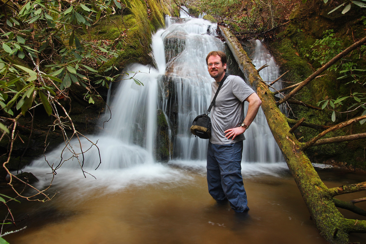
On the downhill stretch, the trail passes by several waterfalls. Most are fairly low flow and cluttered with deadfall making them not very photogenic. However, the last one is definitely worth a closer look.  We took our main break of the day at the top of the falls giving me an opportunity to switch over to my wide angle lens and make my way down to the base for a better look.


According to Darrin, this one does not have a name, so I decided to name it Hamlin Falls. I figure since Darrin puts in many volunteer hours maintaining this trail, this waterfall should be named after him! We will see if this sticks!
 Hamlin Falls

The trail eventually leaves the Mountain Bridge Wilderness and enters into the Ashmore Heritage Preserve. There are several other trails that branch off in this area if you are looking to add a few more miles to the hike, but we just stuck with the main trail.

The trail finishes up by passing through the old Camp Spearhead which was shut down several years ago. I believe this land has been purchased by the Nature Conservancy.  We still had some time left, so Darrin led us to a few other smaller waterfalls and cascades on the old Camp Spearhead property.  This was a nice treat, especially since I did not know these waterfalls even existed!


We also checked out Holiday Lake and some of the old camp buildings.


To finish up the day, Darrin led us to one more nearby waterfall that I was not aware of.  This one is located on Robinson Branch about a half mile up Lawton Road from US276.  Its an short but steep off trail scramble to get to the base of this one.


It was a great day to enjoy the outdoors!

The complete set of photos is posted here:
http://www.flickr.com/photos/8146392@N05/sets/72157633132266784/

Thursday, March 14, 2013

Little Falls Creek Bushwhacking Adventure

Little Falls Creek Bushwhacking Adventure
Mountain Bridge Wilderness, SC
Sunday, March 10th, 2013

There are no trails, but by looking at topo maps and studying the terrain, we just knew there had to be a series of waterfalls on Little Falls Creek!

Andy and Darrin made the first attempt about 2 months ago which led to Andy's dog Boone taking a slide down the 1st waterfall on Little Falls Creek which in now named Boone's Falls!  We are not sure how Boone managed to escape that fall uninjured, but it didn't prevent Andy and I from making a second attempt a few weeks later.

We tried heading up the right side of the creek and did make it a good bit further upstream from Boone's Falls, and could definitely hear some waterfalls and cascades down below.  However, we could never find a safe way down to the creek for a better view.  We eventually gave up and called that attempt a failure!

Andy came up with the idea of trying to access the left side of the creek a little further upstream.  I was not very optimistic about this approach.  Despite the fact that I was expecting another failure, I decided to go along with the idea.  Brenda decided to join us as well.

Andy and the dogs met me in Spartanburg and we rode together to meet Brenda at the Falls Creek Falls trailhead just outside Jones Gap State Park, SC.

Since Andy has already completed and posted his trip report I am not going to do a complete write up.  If you are interested, you can read the complete details of our adventure in Andy's trip report:
Andy's Trip Report
 
Instead, I am going to just post some of the photos.

Note: The waterfalls we found were all on Little Falls Creek.  None of these waterfalls have names, except for #1 which is now named Boone's Falls.  We didn't visit Boone's Falls on this trip, so I will just label these as Waterfall #2 through #7 going downstream to upstream.  Also, there is the possiblitity that we may have missed some, since it was impossible to completely follow the creek all the way upstream.


 Waterfall #2

  Me by Waterfall #3

Waterfall #4 - Left Side

 Waterfall #4 - Right Side

Me by Waterfall #5

Waterfall #6

Waterfall #7
Brenda is in the upper left to give a sense of scale


 Boone

 Kona

Hiking by the remains of an old moonshine operation


The complete set of photos is posted here:
http://www.flickr.com/photos/8146392@N05/sets/72157632976399144/

Sunday, March 10, 2013

Little Falls Creek

Andy, Brenda, Boone, Kona, and I had an awesome waterfall wandering bushwhacking adventure today.  We did some off trail exploring to Little Falls Creek inside the Mountain Bridge Wilderness and found a series of waterfalls.

Here is a quick shot of me by one of the smaller waterfalls we found.


Plenty more to come later this week!


Sunday, March 3, 2013

2013-03-02 Waterfalls and Snow Hike

Waterfalls and Snow
Saturday, March 2nd, 2013

I had a great day of Hiking on Saturday!  I joined my long time hiking buddy Andy and new Hiking buddy Jonathan for some waterfall wandering and snow hiking.  We visited several waterfalls I had not seen before and were treated to a few inches of fresh snow!

Our first stop was Crevice Falls.  This one is on private property, but fortunately the land is not posted.  It is located off of US64 in Sapphire, NC

Me at Crevice Falls

 Crevice Falls

There was only a light dusting of snow at Crevice Falls, so we decided to head north or Hwy215 to hopefully catch a bit more snow cover.  We stopped to check out a couple of roadside waterfalls before our main hike of the day.

 Waterfall on West Fork Pigeon River (aka Garden of the Gods)

 Bubbling Spring Branch Cascades

 Roadside View

Our main hike of the day was a five mile trek into the Middle Prong Wilderness.  A light, but steady snow fell for most of the hike and temperatures were in the low 20s.

Entering the Middle Prong Wilderness

We made it to the base of Mount Hardy Falls before continuing the gradual climb along the Mountains to Sea Trail to a spectacular open bald.

 The base of Mount Hardy Falls


 Distant view of Mount Hardy Falls


It was a great day for a hike!

The complete set of photos is posted here:
http://www.flickr.com/photos/8146392@N05/sets/72157632902314833/

Meet Zoey

 Meet Zoey! Amy and I just adopted this beautiful girl!