Tuesday, November 29, 2016

2016-11-25 Black Friday Hike with Brenda

Moonshine followed by Confusion
A Black Friday Hike with Brenda
Mountain Bridge Wilderness, SC
Friday, November 25th, 2016

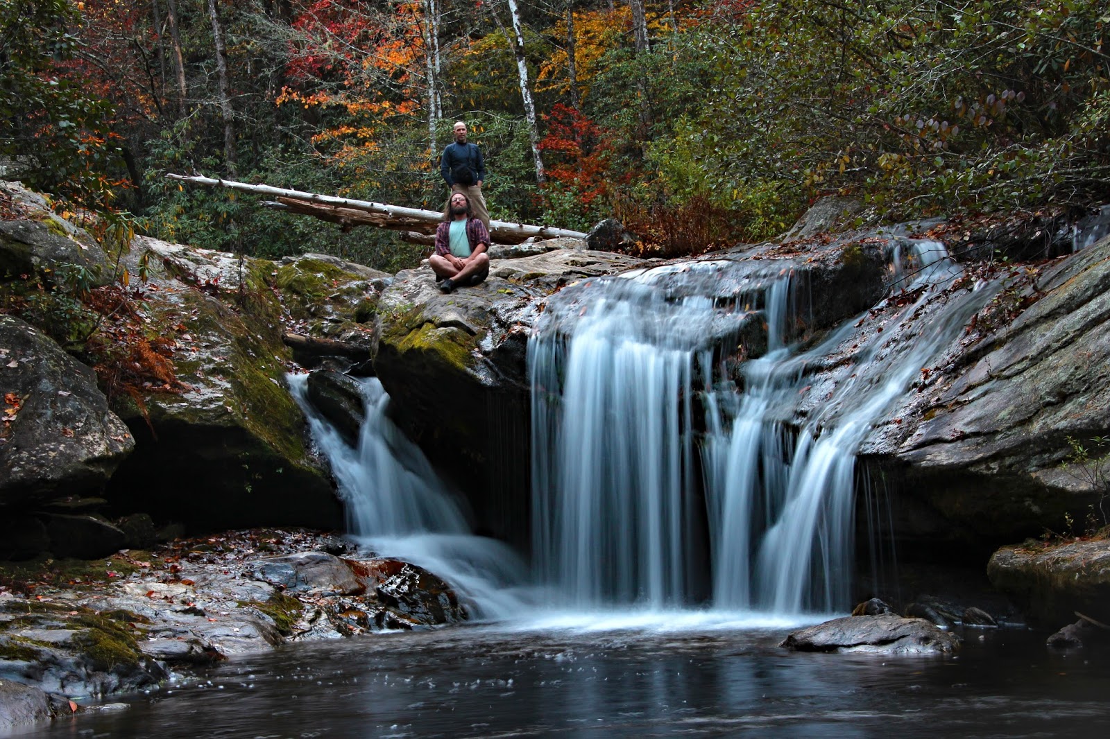
Brenda and Me at Moonshine Falls

For many people, Black Friday is all about shopping, crowds of humans, and traffic hell!  For me it is about exactly the opposite!  It is about getting outside far far away from all the crowds, shopping malls, and all the other holiday craziness!  For my annual Black Friday Adventure, I try to pick a hike where it is highly unlikely that you will run across another person!

Brenda suggested scoping out an alternate bushwhack route down to Moonshine Falls and Confusion Falls.  This sounded great to me since it has been over 10 years since my list visit.  We knew the water flow would be abysmal, but we figured these two falls might look good under much lower than normal flow.

Our meet up spot was a few miles down the Mountain from the Caesars Head overlook so I arrived early enough to make the obligatory overlook stop.  I was surprised that there was still some nice fall color left!
The Caesars Head Overlook

 Some nice Fall Color from the Caesars Head Overlook

I met up with Brenda and we started our bushwhack down from US276. 

Here is the GPS Track of our day.
GPS Track


We basically started out heading west across the ridge line.  The forest is fairly open making for some easy bushwhacking.  Eventually we started downhill and spotted a steel cable tied to some trees. Upon closer inspection this turned out to be a trail with the cables being makeshift hand rails for the steep sections.

 Steel Cable along the mystery trail  (photo by Brenda)

There were even some very obvious blazes on many of the trees
Overlook Trail  ??????

Both of us are very familiar with all the trails in the Mountain Bridge Wilderness, but neither of us had ever heard of The Overlook Trail.  And the blaze is not like any other trail blaze in the area.  We guessed that it either was coming from the Asbury Hills Camp or the Bald Rock Community.

We followed it downhill for a short distance, but it was not heading in the direction we wanted to go, so we left the trail and continued our bushwhack downhill.  Hopefully we would have time to solve the mysteries of this trail later in the day.

As far as bushwhacks go, this one is pretty easy.  As long as you know how to navigate off trail, working your way down the mountain towards Moonshine Falls should not be an issue.

Eventually we made it to the old logging road and followed that to the Moonshine Falls Spur Trail.

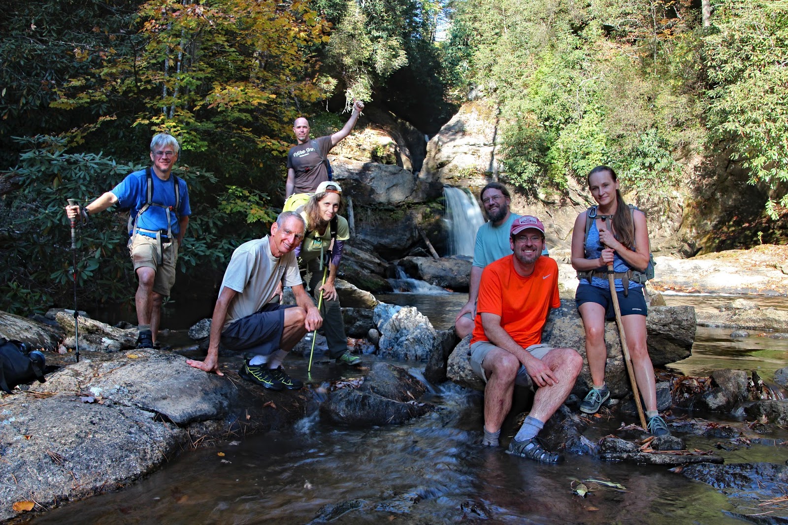
As expected, Moonshine Falls had less water than either of us had ever seen, but it was still rather photogenic.
 
Moonshine Falls

 Brenda at Moonshine Falls

Brenda filling her bottle with Moonshine!

Moonshine Falls

Moonshine Falls
I wonder how this one got its name?

Brenda at Moonshine Falls

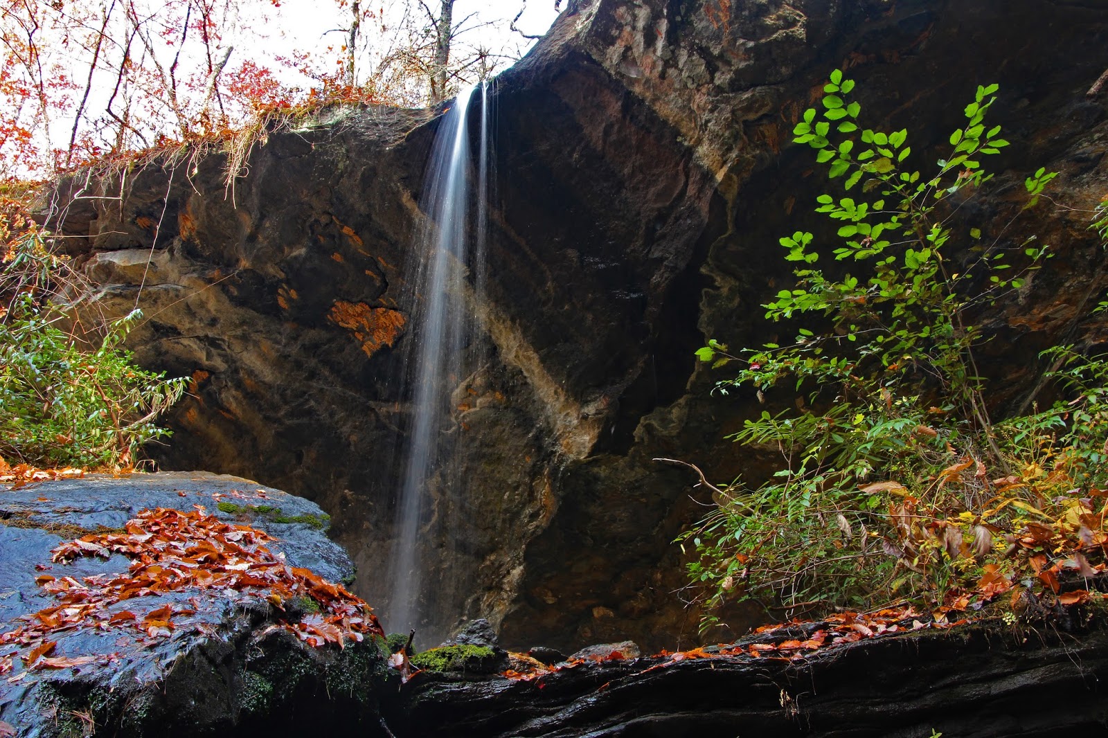
From Moonshine Falls we continued downstream to Confusion Falls on river right.  This turned out to be the most difficult part of the entire day.  However, by utilizing the Brenda Butt Slide Method we were both able to make it to the base of Confusion Falls without any issues


Instead of heading back the way we came, we climbed up the side of the bank on river left to get back upstream.   Neither side is easy, but this was was definitely the shorter route to return back to the old logging road.

We followed a similar, but not exactly the same bushwhack route back up the mountain.  When we reach the mystery Overlook Trail that we stumbled across earlier in the day I wanted to find out where it went. 

Brenda and I decided to split up.  I would follow the trail downhill to the south, while Brenda would continue up hill.

After about a half mile, one of my earlier guesses proved to be correct.  This "Overlook" trail originates from the Bald Rock Community (The bottom loop of the GPS Track posted above).


Mystery solved!  Now to see what is on the other end!


view from the Overlook at the end of The Overlook Trail

 A zoomed in through the trees view of the Pinnacle Mountain Forest Fire

The last of the Fall Color - from the end of the Overlook Trail


From here it was a short bushwhack back up to our starting point.  I was able to catch up with Brenda just as we arrived back at our vehicles parked along the shoulder of US276.

It was a beautiful day to be outside!  Far more enjoyable than any Black Friday Shopping!

My complete set of photos is posted here:
https://www.flickr.com/photos/8146392@N05/albums/72157675606177491

Wednesday, November 16, 2016

2016-11-12 Crowded Mountain and The Pinnacle

Crowded Mountain and The Pinnacle
Crowders Mountain State Park
Gaston County, NC
Saturday, November 12th, 2016

Crowders Mountain

Where should I hike today?  That was the question I had facing me early Saturday Morning.  Since I needed to get back to Spartanburg by 3:30pm my hike destination would have to be relatively close to home.

I almost decided to head up to Lake Lure to capture some photos of the horrific forest fire.  However, seeing that would probably depress me and fresh air sounded more appealing than smoke filled air I decided to head in a direction away from the smoke!

Crowded Mountain is only about 45 minutes away and it has been over 10 years since my last visit.

I figured on a lovely Fall Saturday, Crowded Mountain would live up to it's name so I got a nice early start arriving at the visitors center shortly after they opened the gates.


During the three mile hike which climbs about 700 feet up to the summit of Crowded Mountain I did not run into another human!  I even had the summit all to myself for a few minutes.

view from Crowders Mountain

view of the Charlotte Skyline from Crowders Mountain

Crowders Mountain


As I was exploring around the rocky outcroppings the mountain top started filling up with people.  The population of the Crowded Mountain Summit went from one (me) to about fifty during the twenty minutes I was there!

I descended down the Backside Trail and connected to the Crowders Trail for my return towards the Visitors Center.

I continued by hike along the Pinnacle Trail which climbs about 800 feet over about two miles.

 view from The Pinnacle

The Pinnacle

 View of Crowders Mountain from The Pinnacle


After exploring around and soaking in the various views I headed back down the mountain finishing up my hike on the Turnback Trail, Fern Trail, and Shorts Lake Trail.

A drought stricken Shorts Lake

Some nice Fall Color at Shorts Lake

By the time I made it back to the Visitors Center the parking lot was 100% full and there was a line of about 30 vehicles waiting to get it!  Crowded Mountain definitely lived up to its name today!

Despite the crowds, it was still an enjoyable hike with some beautiful weather!  Total distance was just under 12 miles.


GPS Track of my hike

The Complete set of photos is posted here:
https://www.flickr.com/photos/8146392@N05/albums/72157676519754936

Thursday, November 3, 2016

2016-10-29 Three Forks Adventure

Team Waterfall Backpacking Adventure
Three Forks Area of the Chattahoochee National Forest
Somewhere in the far North East Corner of Georgia
where the Banjos Play!
Saturday, October 29th, 2016

Team Waterfall Group Photo at Thunderdome Falls

As mentioned in my previous post, I forgot my camera when Andy and I went to visit Chasm Falls the previous evening and had to settle for cell phone photos.  Therefore I started the day with a short drive and hike to revisit Chasm Falls with my good camera.  I am glad I did, because I got some much better photos this time under the nice morning light!

 Chasm Falls on the West Fork of Overflow Creek

After Chasm Falls, I returned to the campsite join back up with Andy and to finish packing up.    Andy and I hit the road for the short drive to the Three Forks Trailhead.  Kitty and David were already there when Andy and I arrived about 15 minutes early.

The Team Waterfall Early Arrivals Selfie
L to R:  Me, David, Kitty, Andy

We waited about a half hour before Kitty, David, and I decided to begin the 1.5 mile backpack down to the Three Forks Area to set up camp.  Andy decided to hang back and wait around for the late arrivals.

I had been to Three Forks once before on a dayhike about 7 years ago.  However, this was the first time I have hiked in from this direction.  The first mile was relatively easy, however the last half mile is a bit of a scramble and quite the challenge when carrying a heavy pack, tent, camera, tripod, and cooler full of FABs.
GPS Track of our hike down to the Three Forks Area

However, we made it to Three Forks without any issues and set up camp at an awesome spot where Holcomb Creek, Overflow Creek, and Big Creek converge together to form the West Fork of the Chattooga River!

After setting up camp and exploring around a bit, the others started to arrive.

 Scott and Darrin arrive at Camp

Jennifer Arrives!

After everyone got set up and had a little lunch we started out on our main goal for the day.  An exploration of Big Creek.  These are all fairly high volume creeks, so the extreme drought the area is under makes for the perfect time for some creek walking!

Andy heading up Big Creek

Just upstream from our campsite is the first waterfall on Big Creek.

Waterfall on Big Creek just upstream from our Campsite
Note: photo taken later in the day when the lighting was better

There were a few tricky spots, but with the low water levels it was mostly a fairly easy creek walk.  For some of the larger cascades and waterfalls we did have to bushwhack around a bit.

Here are some of the photos along the way.

Nice Cascade along Big Creek

Scott admiring some awesome fall color over Big Creek

Jennifer in a cool cave alongside Big Creek

Darrin arriving at a nice cascade along Big Creek

Kitty

Darrin, Kitty, Jennifer, Andy 

Waterfall on Big Creek

 Darrin photographing a Waterfall on Big Creek

Jennifer and Andy

Darrin, Kitty, and Jennifer approaching Thunderdome Falls
This is the only shot I got where you can come close to seeing all three tiers

Thunderdome Falls

Thunderdome Falls

Darrin "The Salmon" Swimming at Thunderdome Falls

Thunderdome Falls
(can you spot Andy?)

Group Photo at Thunderdome Falls
L to R:  David, Andy, Darrin, Kitty, Scott, Jennifer, Me

For the return to the campsite we picked up a faint path well up the bank on River Right.  This was not quite a trail, but not quite a bushwhack either.  It was much quicker than creek walking and we returned to Three Forks with plenty of daylight left.

So we decided to explore a short ways up overflow creek.  We were on a good trail for a short way, but when that fizzled out and the going got tough we ultimately decided not to push on and returned to camp.  Here is the GPS track from our Big Creek Adventure!


GPS Track from our Adventure up Big Creek


After we returned to camp, there was still some daylight left to explore the area close to the campsite under prime photography light!


 Small Cascade across from a sandy campsite on the West Fork of the Chattooga

 The West Fork of the Chattooga River

 Scott and Darrin at a Waterfall on Holcomb Creek Right next to our Campsite

  The West Fork of the Chattooga River

 The West Fork of the Chattooga River

The rest of the evening was spent hanging out with my awesome Team Waterfall friends.  Unfortunately due to the extreme drought there is currently a ban on campfires in the area.  Therefore I will not be able to post any campfire photos.

At one point we were taking bets as to what time Spencer and Stephanie would arrive.  Jennifer guessed 10:30pm.   At exactly 10:30pm we spotted lights coming down the hillside towards Three Forks.  Shortly after Spencer, Stephanie, and Preston arrive at camp!  And the party went on for several more hours!

The Complete set of photos from Saturday is posted here:
https://www.flickr.com/photos/8146392@N05/albums/72157672424170894


Meet Zoey

 Meet Zoey! Amy and I just adopted this beautiful girl!