Tuesday, May 31, 2011

Opossum Creek Falls

Amy and Jack's Memorial Day Weekend Getaway to Georgia

Chapter 2 - "A Busload of Bikini Babes"
Oconee County, SC
Saturday, May 28th, 2011


Opossum Creek Falls

Opossum Creek Falls is one that I have been wanting to get to for years, but have never gotten around to visiting.
Opossum Creek Falls

A little bit of pre-trip research revealed that there is quite a bit of conflicting information out there on the Internet. Some sources rate the trail as "Easy" while others rate it as "Strenuous" or "Difficult". Also, the mileages listed are anywhere from 1.5 miles to 5.0 miles. My most trusted sources of information led me to believe it was something Amy would be able to handle.

We had no trouble finding the trailhead, but I was a little disappointed to see a large bus in the parking area. I don't like crowds and I wasn't expecting to run into a whole lot of people on this hike.

The Bikini Babe Bus

The trail starts out by gradually descending from the road into the forest, before leveling out for a good ways and eventually meeting up with Camp Branch. There was a pretty good display of wildflowers along the trail which probably would have been even better a few weeks earlier.

Wildflowers along the Trail

After about a mile, the trail starts descending again and Camp Branch becomes a long series of cascades. Many of these cascades looked like they might be worth checking out, but they would all require a steep scramble down from the trail.

We hadn't seen a single other person along the trail, but as we got closer to the river we could hear a large group of people having a good time down by the river. Again, I don't really like crowds! Unless of course the crowd consists largely of a bunch of college girls in Bikinis!

Bikini Babes at the Chattooga River

Amy didn't seem as impressed as I was?

From the Chattooga River, the trail turns left and heads through a few campsites where Opossum Creek enters into the Chattooga River. Don't cross Opossum Creek, but instead take the trail upstream on the left side of the creek.

After a short distance the trail rock hops across the smaller Camp Branch shortly upstream from where Camp Branch merges into Opossum Creek. The most difficult part of this crossing was avoiding getting slapped by my wife as we passed by several more bikini babes bathing in the creek.

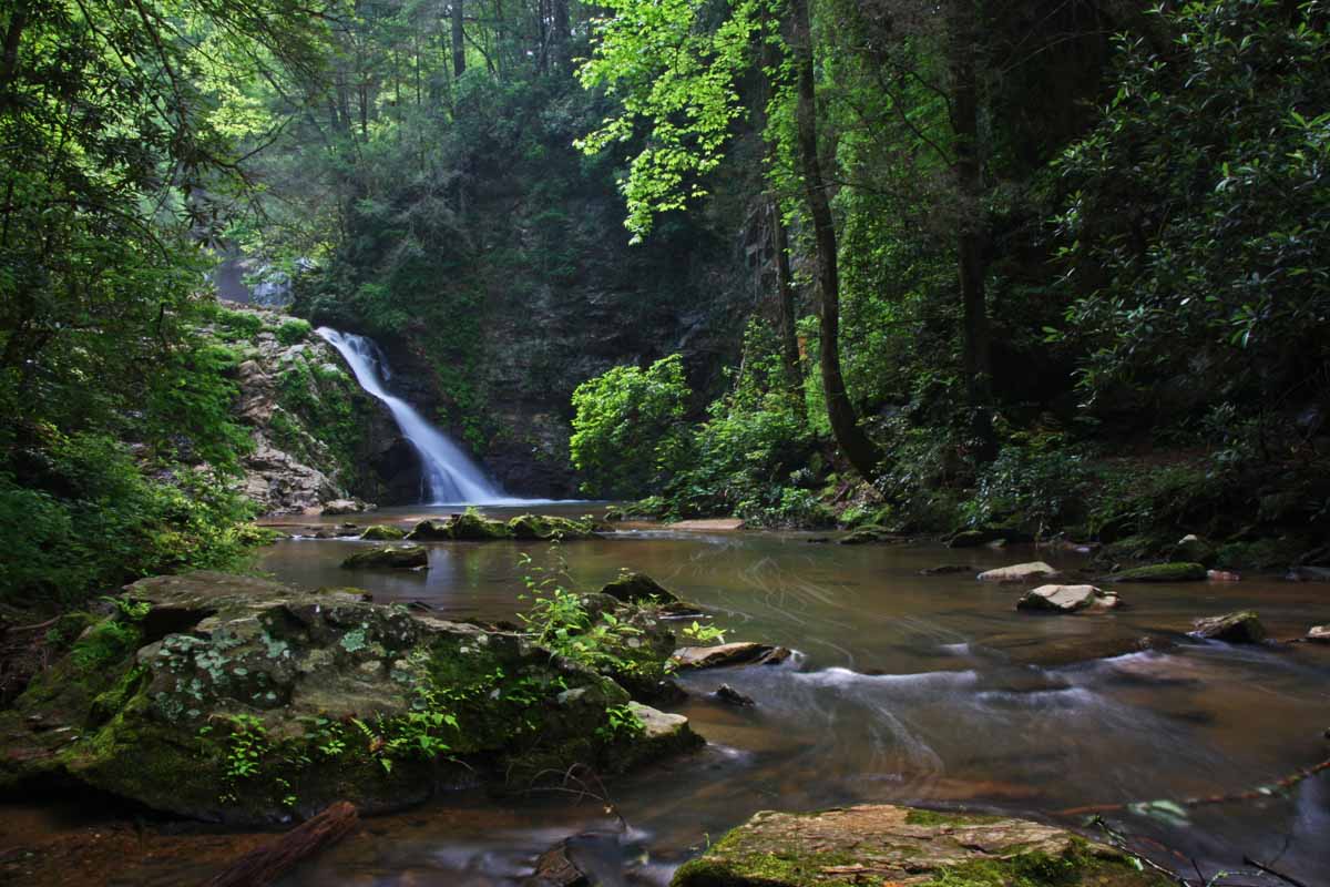
After crossing Camp Branch, the trail continues up along the larger Opossum Creek. The final stretch of trail gets a bit rocky and some minor scrambling is required to make your way to the base of Opossum Creek Falls.
Jack and Amy at Opossum Creek Falls

This is a really nice 50-foot waterfall! Unfortunately the bright sun did not make for optimal photo conditions. I kept hoping for a stray cloud to move in front of the sun for a few minutes, but it never happened.  A few more Bikini Babes showed up to make things a little better.

Bikini Babe at Opossum Creek Falls

The hike out wasn't too bad except for the 90-degree temperatures and near 100% Humidity.  It didn't take much to convince Amy that we needed to stop for Ice Cream after the hike!

The full set of Opossum Creek Falls photos is posted here:
http://outdoors.webshots.com/album/580279760sOVNDx


After completing the hike, this is what I believe to be accurate information:
Mileage = 5.0 miles round trip
2.2 miles to the Chattooga River + an additional 0.3 miles to the waterfall = 2.5 miles one way

Difficulty = Moderate.  The trail drops approximately 700-feet of elevation over the first 2.2 miles down to the Chattooga, meaning that you have to re-gain those 700-feet on the hike out.  The final short stretch to the base of the waterfall requires some minor scrambling.

Directions:
1. From Westminster, SC head west on US76 for 13.3 miles (1.3 miles past the turn for Brasstown Falls).
2. Turn left onto Damascus Church Road just before the Long Creek Fire Station
3. Drive 1.9 miles and turn right onto Turkey Ridge Road (FS755). Turkey Ridge Road is dirt/gravel but is drivable in just about any vehicle
4. Drive 2.3 miles and look for the trailhead on the left. Small pulloff/parking areas are located on both sides of the road just past the trailhead.

Monday, May 30, 2011

Brasstown Falls

Amy and Jack's Memorial Day Weekend Getaway to Georgia

Chapter 1 - Brasstown Falls
Oconee County, SC
Saturday, May 28th, 2011

Last month for one of my birthday gifts, Amy booked a weekend stay at a Bed and Breakfast in Northern Georgia.

We just got back from our little weekend getaway and I have over 700 photos to go through.  Rather than going through them all and writing the complete trip report at once, I am going to do it in batches starting with the first stop of our trip.


We left Spartanburg early Saturday Morning.  Since we would not be able to check in until after 3:00pm, I planned a few stops along the way, Brasstown Falls being the first.

I visited Brasstown Falls once about 6 years ago and I have been wanting to get back with the new camera (not actually new anymore, but still newer and better than the one I had during my last visit). 


Middle Brasstown Falls (aka Brasstown Veil)

The Brasstown Falls trail is very steep, but since it is only about a quarter mile long, I knew Amy could handle it.  It descends about 200-feet in elevation passing by three significant waterfalls along Brasstown Creek.  They are close enough together that there are spots along the trail you can actually see all three drops at the same time, but for photo purposes it is best to view them individually. 

I decided to save the picture taking until we got to the bottom and then work our way back up.  Lower Brasstown Falls (also know as Brasstown Sluice) is about 35-feet tall and is much larger than my photos show.  The entire creek volume is squeezed into a narrow channel dropping diagonally down the rock wall.

Lower Brasstown Falls  (aka Brasstown Sluice)


Middle Brasstown Falls (aka Brasstown Veil) is also about 35-foot tall, but is completely different from the lower falls.  Here the creek is spread wide and the drop is a free fall instead of a slide. 


Middle Brasstown Falls  (aka Brasstown Veil)

Side view of Middle Brasstown Falls


The upper drop consists of a series of cascades totaling about 50-ft high.  It is my least favorite of the three falls, but still a very scenic and photo worthy waterfall.  Especially when the Rhododendron and Mountain Laurel are blooming along side.

Upper Brasstown Falls (aka Brasstown Cascades)


Besides the fact that this is one of the greatest series of waterfalls in South Carolina, Another reason why I wanted to make a return visit to Brasstown Falls is to find Little Brasstown Falls, which I didn't know existed back when I first visited. 

Little Brasstown Falls is not on the main creek, but a smaller tributary stream.  However, it does require crossing Brasstown Creek.  Amy elected to pass on that, but I managed to find a spot where a few fallen trees gave me a safe and dry crossing.

Little Brasstown Falls is a nice added bonus and I bet it would be really awesome if you caught it right after a heavy rain.
Little Brasstown Falls


Memorial Stone at the base of Little Brasstown Falls

 
The complete set of Brasstown Falls Photos are posted here:
http://community.webshots.com/album/580273792eRXEdv


Directions:
1. From Westminster, SC head west on US76 for about 12 miles and turn left on Brasstown Road
2. Drive 4.2 miles (dirt for last 1.5 miles, but drivable in just about any type vehicle) and turn right onto FS751 (just before a small bridge)
3.  Drive to end of FS751 (about a half mile) and park.  (note:  the parking area can get very tight and crowded during busy weekends so plan your visit early in the day or during a week day)
4.  The trail is obvious and follows the creek downstream.  Parts of the trail are very steep and will require the use of all four limbs!  If you don't like scrambling, you might want to skip this.  Also not recommended for small children.
5.  The "trail" ends at the base of the Lower Falls.
6.  For Little Brasstown Falls, check out the campsite just before the main trail starts descending downhill.  You should be able to see the tributary creek and waterfall upstream.  Find the best place to cross the main creek and work your way upstream to the waterfall.

Saturday, May 28, 2011

Jack and Amy at Oppussom Creek Falls

Amy and I took a trip up to Oconee County, SC today to visit some waterfalls.  Here is a shot of us at Oppussom Creek Falls.

Tuesday, May 24, 2011

Exploratory Hike to Drawbar Cliffs
With the Upstate Hiking and Outdoor Adventures Group
Pickens County, SC
Sunday, May 22nd, 2011

Group Photo at Drawbar Cliffs
L to R:  Tim, Bren, Jack, Caroline, Clint


Photos are posted here:
http://outdoors.webshots.com/album/580240256BIEtIc

Drawbar Cliffs is located along the Foothills Trail about halfway between the Table Rock State Park Trailhead and the Sassafras Mountain Parking Area. We could have simply started at either of these trailheads, but we wanted to see if we could get there a different way.

Five of us started at Hwy11 about 2 miles east of the US178 intersection. The map we were using calls this Alewine Road, but most maps don't show any road/trail here. We parked along the shoulder of Hwy 11 and began our hike up the gated SCDNR dirt road.

Rhododendron Blooms along the trail

Alewine Road, while not very exciting, offers several benefits and opportunities. It joins up with the Palmetto Trail about 4 miles west of the Table Rock Trailhead, allowing much shorter access to the center of this stretch of trail. Plus you avoid having to pay the $2.00 per person State Park entrance Fee.

Another potential opportunity for Alewine Road that I plan to explore on a future trip is potential access to Rachel Creek Falls:

Last year my buddy Waterfall Rich of http://www.ncwaterfalls.com/ posted about a waterfall on Rachel Creek. Unfortunately the route he took to get there crosses private property.  I believe that Alewine Road would be a good place to start a bushwhack to Rachel Creek Falls without ever leaving the Public SCDNR gamelands.

Today we used Alewine Road to connect to the Palmetto Trail where we turned left (West). We could have stayed on the Palmetto Trail, but we chose to cut off a bit of distance and instead turned onto Camp Adger Road which after about a half mile joins back up with the Palmetto Trail.

Our plan was to take the old Emory Gap Toll Road to the Foothills Trail. We crossed Emory Creek and continued for about a half mile before we realized that we completely missed the turn for the Emory Gap Toll Road.


Tim crossing Emory Creek


One good thing about our missed turn is that because of it, we spotted the largest trillium I have ever seen!

The Largest Trillium I have ever seen

After backtracking about a half mile and crossing back over Emory Creek we arrived at an open field we passed through earlier. It turns out that the Emory Gap Toll Road starts at the North End of this field. It is not at all obvious if you do not know where to look, but once you are on the old Toll Road it is very easy to follow.
The start of the Emory Gap Toll Road


This section of the Emory Gap Toll Road gains about 1,000 feet of elevation over the course of about a mile, making for a very steep climb. On top of that, we were hiking on what was the hottest day of the year so far. We were all sweating up a storm, but we eventually made it to the Foothills Trail where we stopped for a nice break.

We took the Foothills Trail East for about a mile to the point right along the Table Rock State Park Boundary where the trail makes a long switchback up to Drawbar Cliffs.
view from Drawbar Cliffs

The views from Drawbar Cliffs definitely did not disappoint and we took a nice long lunch break to soak it all in.

Iggy goes out on a Limb at Drawbar Cliffs

After lunch, we backtracked a short distance on the Foothills trail and turned onto Long Ridge Road. After a short distance, an arrow along the trail pointed to the right. We went to check out what the arrow was pointing to and found another nice viewpoint. Not quite as good as Drawbar Cliffs, but still and impressive an unexpected surprise. We decided to call this spot Arrow Bald.


Arrow Bald

Long Ridge Road continued to offer up some unexpected impressive scenery. It reminded me a little of the Cedar Rock/Big Rock Areas of DuPont State Forest. I would definitely recommend the Long Ridge Road over the Emory Gap Toll Road for any future hike planning!

Long Ridge Road


Since we were now going mostly downhill and the return route was a little shorter, we made much better time coming back.

Although I would have preferred it to be about 30 degrees cooler and about 50% less humidity, it was still a very enjoyable hike. We travelled a total of about 10 miles and only saw one other group of hikers the entire day.
Our Hike Route (highlighted in yellow)

The complete set of photos is posted here:
http://outdoors.webshots.com/album/580240256BIEtIc

Monday, May 23, 2011

A few photos from Sunday's Hike to Drawbar Cliffs

Interesting Wildflower.  Anyone know what it is?

View from Drawbar Cliffs

Tim and Caroline on Drawbar Cliffs


Trail Toad

Sunday, May 22, 2011

Iggy at Drawbar Cliffs

Iggy and I went hiking with a few others today to a place called Drawbar Cliffs.

Iggy at Drawbar Cliffs

I'll post some more photos for our hike tomorrow!

Thursday, May 19, 2011

The SSPBDTSOCT

Mortimer Campground at Wilson Creek
Caldwell County, NC
Friday, May 13th thru Sunday, May 15th, 2011

Photos are posted here:
http://outdoors.webshots.com/album/580213880fgXcuV

Since the SSPBDT (Spartanburg Steel Products Beer Drinking Team) was established, we have organized an annual Mancation Camping Weekend each October. The Fall Mancation is strictly a men only event. Except for a few broken bones, the Mancation has always been a huge success.

Several years ago a few of our wives decided that they wanted to join in on the camping fun. So we started the Spring SOCT Event (Significant Other Camping Trip). This is where our wives, significant others, and children are allowed to come along.

This year would be the third SSPBDTSOCT

Scott M holding up the Official Super Accurate Mortimer Campground Map


The Moore's (Scott, Malinda, and Christopher) were the first to arrive and successfully commandeered our favorite group gathering site at the far back end of the Mortimer Campground. Amy and I arrived next and snagged a few other neighboring sites.

Shortly after Amy and I set up our tent, the Martin's (Jeff, Lorie, and 1-year old Austin) arrived.

Lorie and Austin

Also arriving was the sounds of thunder and some ominous looking clouds.

Throughout the long history of SSPBDT camping trips there has never been a weekend without rain. Fortunately we have "The Giant Tarp". The giant tarp erection is an amazing feat of engineering marvel. The original plan was to wait until our leader Steve-O showed up before starting the erection process. But, with certain rain heading our way Scott M., Jeff, and I decided to mount the giant erection on our own.

Trying to Get It Up!

The three of us managed to get it up without any broken bones or other mishaps. Steve-O arrived with his two rug rats shortly after the tarp was erect and was very impressed with our ability to get it up without him.


Eventually the Rosenberger's (Scott, Karen, and Carley) arrived to make the total size of our group at fourteen.  The rain eventually did arrive and stuck around throughout the evening. We were very grateful for the tarp as we gathered underneath and around the campfire sharing food, stories, and plenty of FABs late into the night!
Steve-O sounding the SSPBDT Trumpet


Alcohol Abuse!  Scott M. spilling several ounces of FAB goodness!


The rain had stopped by morning but all my clothing from the previous evening was soaked! I went to change into some fresh clothes, but I could not find any socks in the bag that Amy packed for me. Eventually Amy emerged from the tent and confirmed that she forgot to pack any spare socks for me!

The closest bit of civilization is Morganton, NC about 45 minutes away. I wasn't about to make the hour and a half round trip drive, so instead Amy and I decided to try "Walker's Country Store" about 5 miles down the road from the campground.

Amy at Walker's Country Store

This is no Wal-Marts, but for $2.75 we managed to pick up a package of (3) socks. They were probably the cheapest socks ever manufactured, but socks is like sex. Bad socks is better than no socks!

Also at Walker's Country Store I got myself a cup of coffee, a few bags of ice, and a weather forecast of more rain later in the day!


I had originally planned to go hiking, but really didn't feel like being out on the trail when the rain arrived. However, for the moment things were clear and the previous evening's rain had raised the level of Wilson Creek high enough to Kayak, which made Scott R. very happy.

Carley and Christopher at Wilson Creek

Out of all the trips I've made to the area, I have always gone hiking and never taken the time to check out the Kayakers. So Amy and I decided to join some of the others to watch Scott R. and a few of his buddies Kayak down Wilson Creek.

Scott R. Kayaking down Wilson Creek

Amy and I also took a few short strolls around the area to check out some of the Mortimer Ruins and also Thropes Creek Falls.

Amy by some of the Mortimer Ruins


Jack and Amy at Thorpes Creek Falls

Eventually the rain came and the group gathered under the tarp for most of the evening. There was a small break after a fairly heavy stretch of rain where I went to check on the tent.

I have never owned a 100% leak free tent and this one is no exception. One thing I attempted this time to hopefully help the situation was to put up a canopy over the tent.

Our Canopy / Tent Set-up

Unfortunately any bit of wind creates a pocket in the canopy cover where the rainwater gathers up. I discovered about 150 gallons of water pooled on the canopy cover. The entire set-up appeared very close to collapsing and crushing our tent.

While attempting to relieve the pressure and shed the water without dumping the water all over the side of the tent, I managed to dump all the water on top of myself!

I was able to prevent disaster to our tent, but my clothing was soaked. While trying to change clothes I accidentally dropped my pair of dry socks into a giant puddle. I hadn't even started drinking yet, but I took all this as a sign that it was time to get started!

Between all of us, we managed to bring plenty of firewood and Steve-O was determined to use it all up. He built an enormous fire which was great except for the fact that it wasn't cold outside and in order to get a comfortable distance away from the fire you had to go beyond the protection of the tarp out into the rain. The only solution to this dilemma was to have a few more FABs.

Around the Campfire

Again the party went on late into the night and I am not going to mention some of the crazy antics that occurred!

It rained most of the night, but fortunately our tent and canopy held up and by morning things had cleared up. Of course there was no avoiding the mess of packing up wet camping gear! I wonder what it is like to pack up dry camping gear?

As always, despite the rain, we had a great time. Even though Amy does not enjoy camping like I do, she was a good sport. Time will tell if I will be able to convince her to join me again at next years SSPBDTSOCE.

The complete set of photos from our camping weekend is located here:
http://outdoors.webshots.com/album/580213880fgXcuV

Tuesday, May 17, 2011

A few more photos from this weekends camping trip

"10-Foot Falls" on Wilson Creek


Austin Crawling around the campground


Ladybug


Thorpes Creek Falls


Hopefully I will get the trip report completed and full photo set posted tomorrow!

Monday, May 16, 2011

A few photos from our weekend camping trip

Wilson Creek Camping Weekend
Caldwell County, NC
Friday, May 13th, 2011 thru Sunday May 15th, 2011


Wilson Creek


Austin enjoying his first camping trip


Scott R. navigating "Boat Buster Rapids" on Wilson Creek


A pair of Butterflies


Carley hanging out at Wilson Creek


Lots more to come!

Meet Zoey

 Meet Zoey! Amy and I just adopted this beautiful girl!