Wednesday, September 26, 2018

2018-09-22 Elliotts Cabin Weekend

Team Waterfall Gathering at Elliott's Cabin
Spring Creek, Squirrel Branch, Caboose Falls.
Max Patch Sunset and Sunrise
Madison County, NC
September 22nd and 23rd, 2018


Group Photo at Elliott's Cabin

My buddy Elliott invited our Team Waterfall group up to his Cabin for the weekend!

A bunch of us met up Saturday Morning in Hot Springs, NC for an  exploratory hike along Spring Creek and Squirrel Branch in search of new waterfalls.

 Captain John

 Jill, The Badger, and Kitty

The Professor

 The Badger and Captain John


Part of the Team Waterfall experience is studying topo maps, identifying places where waterfalls might be, and planning the best way to access these spots.  These undocumented waterfalls we find almost always requires creek walking and or bushwhacking.

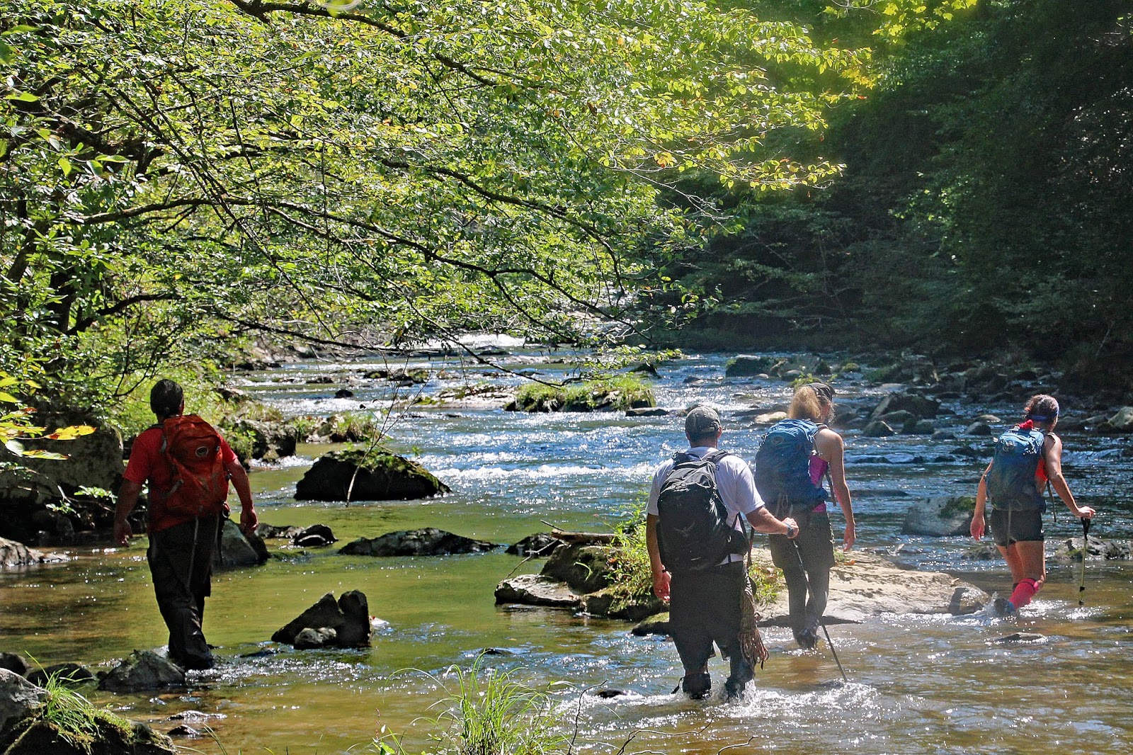
Creek Walking along Spring Creek
We don't need no trail!  


Many times our efforts are rewarded with some spectacular waterfall discoveries.  Today, was not one of those days! 

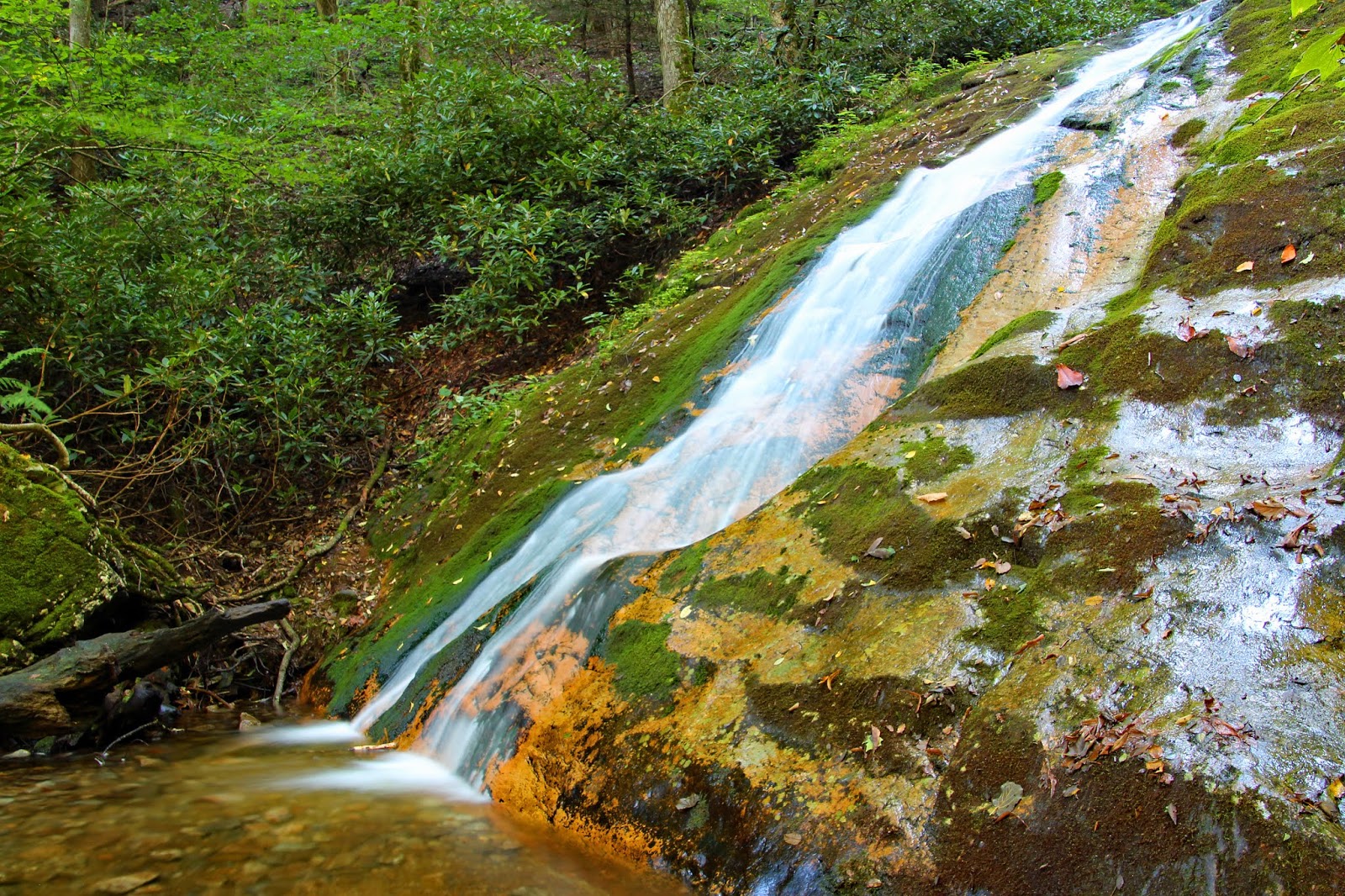
Squirrel Branch had much lower flow than we were expecting and there was not really any significant drops along the stretch we explored.   The closest thing we found to a legitimate waterfall we named Caboose Falls.

Captain John at the top of Caboose Falls


Next up the group moved on to a nice swimming hole along Spring Creek where several more Team Waterfall members joined us for a few hours of just hanging out and having fun.
 
Badger Group Selfie along Spring Creek

 The Professor

Ziggy and Luna

Kyle

Angelina

Most of the Group hanging out along Spring Creek near Hot Springs, NC


From there we continued on to Elliott's Cabin.

 Hanging out at Elliott's Cabin

 Me with the Badger and Spencer

 Carlos, the newest official member of Team Waterfall

 Hanging out at Elliott's Cabin

The Badger, Spencer, and Captain John

Elliott's Cabin is about a 2 mile (4 mile round trip) hike to the summit of Max Patch where our group enjoyed a magical sunset! 

Max Patch Sunset

 Max Patch Sunset

 Max Patch Sunset

 Jill enjoying the Sunset from Max Patch

 Group Photo
L to R:  Captain John, Michelle, Cody, Kyle, Angelina, 
Me, Jill, Elliot, Carlos, Professor Scott, Spencer
 
Michelle and Cody showing off their Yoga Skills

The rest of us showing off our lack of Yoga Skills
(photo by the Badger)

Spencer and The Professor

 Kitty and The Badger

The hike back to Elliott's cabin was well after dark, but a full moon gave just enough illumination that our headlights were not necessary!

We spent the rest of the evening hanging out around the campfire at Elliott's Cabin!  A perfect way to end an awesome day!

The next morning, I was the only one up early, so I did a solo hike back up to Max Patch for the Sunrise!  It was well worth getting up early for!

 Sunrise along the Appalachian Trail

 Max Patch Sunrise

 Max Patch Sunrise

 Max Patch Sunrise

 Max Patch Sunrise

 Hiking the Appalachian Trail back down to Elliot's Cabin


This was an amazing weekend!  Thanks to everyone that helped make it the epic event that it was!  Especially Elliott for hosting us all at his awesome cabin!

The complete set of photos is posted here:
https://www.flickr.com/photos/8146392@N05/albums/72157701727210565


Tuesday, September 18, 2018

2018-09-13 Rock Creek and Dick Creek Falls

The Waterfalls of Rock Creek and Dick Creek
Unaka Mountain Wilderness
Unicoi County, TN
with Mark and Brenda
Thursday, September 13th, 2018

Me and Mark at Dick Creek Falls #1

I decided to take Thursday off from work to get a little hiking in before Hurricane Florence arrived.  The waterfalls on Dick Creek have been on my to do list for a while, so Brenda, Mark, and I planned a hike to check them out.

We started our hike at the Rock Creek Recreation Area Campground.  Almost immediately, we saw signs for Rock Creek Falls which was not part of our original plan.  But since none of us has been to this one, we decided to check it out.

About 2 miles from the trailhead we arrived at Lower Rock Creek Falls.  A short scramble path down from the main trail takes you to the base of this one.

Lower Rock Creek Falls

 Lower Rock Creek Falls


Shortly up the trail we saw what we thought was the Upper Falls so we bushwhacked down to it.  Turns out it is not the Upper Falls, but it is a separate and significant enough drop that we are calling it Middle Rock Creek Falls.

Mark, Brenda, and Me at Middle Rock Creek Falls

Middle Rock Creek Falls

At about 3 miles from the trailhead, the Rock Creek Trail ends at Upper Rock Creek Falls.  This one was much more impressive than any of us was anticipating!  I figure it would be really spectacular with higher water flow!

Upper Rock Creek Falls

 Mark and Me at Upper Rock Creek Falls

 Mark at Upper Rock Creek Falls

 Upper Rock Creek Falls Selfie

 Mark at Upper Rock Creek Falls

The climb up to Upper Rock Creek Falls was over 1,000 feet in elevation gain.  This is about all that Brenda wanted to tackle, so she decided to hang back, take a more leisurely pace back to her vehicle, and let Mark and I explore Dick Creek on our own.

Here is the GPS Track from our hike:


There are multiple drops along Dick Creek.  I am calling the one furthest downstream Dick Creek Falls #1.  We hit them in order heading upstream starting with #1.

 Dick Creek Falls #1

 Dick Creek Falls #1

Once you get past #1, there is not much of a trail anymore, but it is a fairly easy bushwhack upstream to Dick Creek Falls #2.  I was a little disappointed in the amount of water flow.  Photos I have seen of this one show it to be much more impressive with higher flow!

 Dick Creek Falls #2

The bushwhacking/scrambling gets more difficult above and beyond Dick Creek Falls #2.  However, the effort pays off as #3 is the tallest of the bunch!

 Dick Creek Falls #3

The cave at the base of Dick Creek Falls #3

Mark has been to the first (3) on Dick Creek, but during his last trip he somehow missed #4!  So we were not heading back until we found it!  As a bonus, Dick Creek Falls #4 has a real nice swimming hole which we both took advantage of!

 Mark and Me at Dick Creek Falls #4

 Mark and Me at Dick Creek Falls #4

There are more drops upstream, but it is my understanding that they are not really worth the effort, especially compared to the main drops downstream.  Therefore we decided to turn back after #4.

We arrived back at the trailhead to find Brenda stretched out in the back of her SUV enjoying a nice nap!

We decided to end the day with a stop in Asheville, NC for some grub and a few beverages at Ben's Tune-Up!

 Mark, Brenda, and Me at Ben's Tune-up
Asheville, NC

The food was excellent but the service was a bit slow, especially considering it wasn't very busy.  I also got a sampler flight of the Sake that they brew on site!  Very interesting and I am glad I tried it, but I think I will stick with traditional beer.

This turned out to be an awesome day!

My complete set of photos is posted here:
https://www.flickr.com/photos/8146392@N05/albums/72157671257634467


Meet Zoey

 Meet Zoey! Amy and I just adopted this beautiful girl!