Monday, May 23, 2016

2016-05-21 Jordan Lake, NC

Jordan Lake Hike
with Amy, Jenny, Hugh, Grace, and Caroline
Chatham County, NC
Saturday, May 21st, 2016 

Group Photo at Lake Jordan

This weekend Amy and I made the trip up to Chapel Hill, NC to visit Amy's Sister Jenny and her Family.
 

On Saturday we took a drive down to Jordan Lake for a leisurely little 3-mile hike. 

We hiked the Blue Trail at the New Hope Overlook area of Jordan Lake.

Here are a few photos from our hike: 

The Island of Dead Trees

Grace taking a photo

Jordan Lake

 Caroline


 Caroline, Hugh, and Grace

Jordan Lake

Bald Eagle

Amy and Jack (me)

Jordan Lake


The Complete set of photos is posted here:
https://www.flickr.com/photos/8146392@N05/albums/72157668789886275


Thursday, May 19, 2016

2016-05-14 Team Waterfall Adventure

August Cave, Pathertail, the Devils Elbow,  and the Mighty Tuck!
A Team Waterfall Adventure
In and Around Pathertown Valley
Transylvania and Jackson County, NC
Saturday, May 14th, 2016

Badger Team Waterfall Group Selfie to start the day
Photograph by Thomas "The Badger" Mabry

For Saturday's Team Waterfall Gathering, Josh planned a 2-part Adventure starting with the exploration of August Cave.

August Cave is relatively unknown and we have been asked to keep it that way by not divulging it's location.  It is far from any trail and requires a steep uphill bushwhack to get to.  It is highly unlikely that anyone is just going to stumble across it.

I have a slight bit a claustrophobia, so caves are not really my thing.  However every once in a while I like to push beyond my comfort zone to experience something new.  This was one of those times!
Me inside August Cave - Photo by Thomas "The Badger" Mabry

Andy climbing through August Cave

Thomas "The Badger" Mabry and Scott "The Professor" Burns inside August Cave


Next on the agenda would be a climb up Panthertail Mountain via a route that quite possibly no other humans have ever taken!  At times I had serious doubts about being able to make it up and around the shear cliff face of the Panthertail.

Scott admiring the overhanging cliffs of The Panthertail

However we persevered and found a safe route around every obstacle aided by the fact that each hurdle we overcame made the thought of being turned back less and less appealing!

Andy taking a shower at Four Foot Falls

It took us about 3 hours to travel about a half mile, but eventually we made it to the summit of Panthertail Mountain.  Although it does not show up on most maps, there is actually a trail near the summit.  It certainly was a relief to be hiking on an actual trail for a while!

From here, some of the group wanted to wait for Spencer and Stephanie (who started several hours behind us) and explore some more of the cliffs and views from Panthertown Mountain.  While others wanted to continue on with the original plan for the day.  So we decided to split into two smaller groups.

Awesome view from Panthertail Mountain
Note:  the group that met up with Spencer and Stephanie and further explored the Panthertail Cliffs found some even better views!


I continued on with Josh, Wally, Stan, Darrin, Bob, and Thomas.  We were already well behind schedule so we decided to skip the climb to High Bethel on Cold Mountain.  Instead we took the shortest and most direct route to the Devil's Elbow, a faint footpath over Shelton Pisgah Mountain.

Shortly before arriving at the Devil's Elbow we were treated to another nice view.

 view from the trail to the Devil's Elbow!

Once at Devil's Elbow, we had a decision to make.  Our remaining group of seven, split again into five and two.  Thomas and Bob decided to skip the steep bushwhack and river walk and instead elected to stick to the trail and wait for us at Jawbone Falls.

The remainder of us took an extremely steep bushwhack / butt slide down the north side of Devil's Elbow about 500 feet straight down to the Tuckasegee River!

It had been several hours since we last saw water and we were all dying of thirst!  All I have to say is "Thank God For Life Straw!"  (The official water filtration system of Team Waterfall).

Thank God For Life Straw - Darrin and the Mighty Tuck

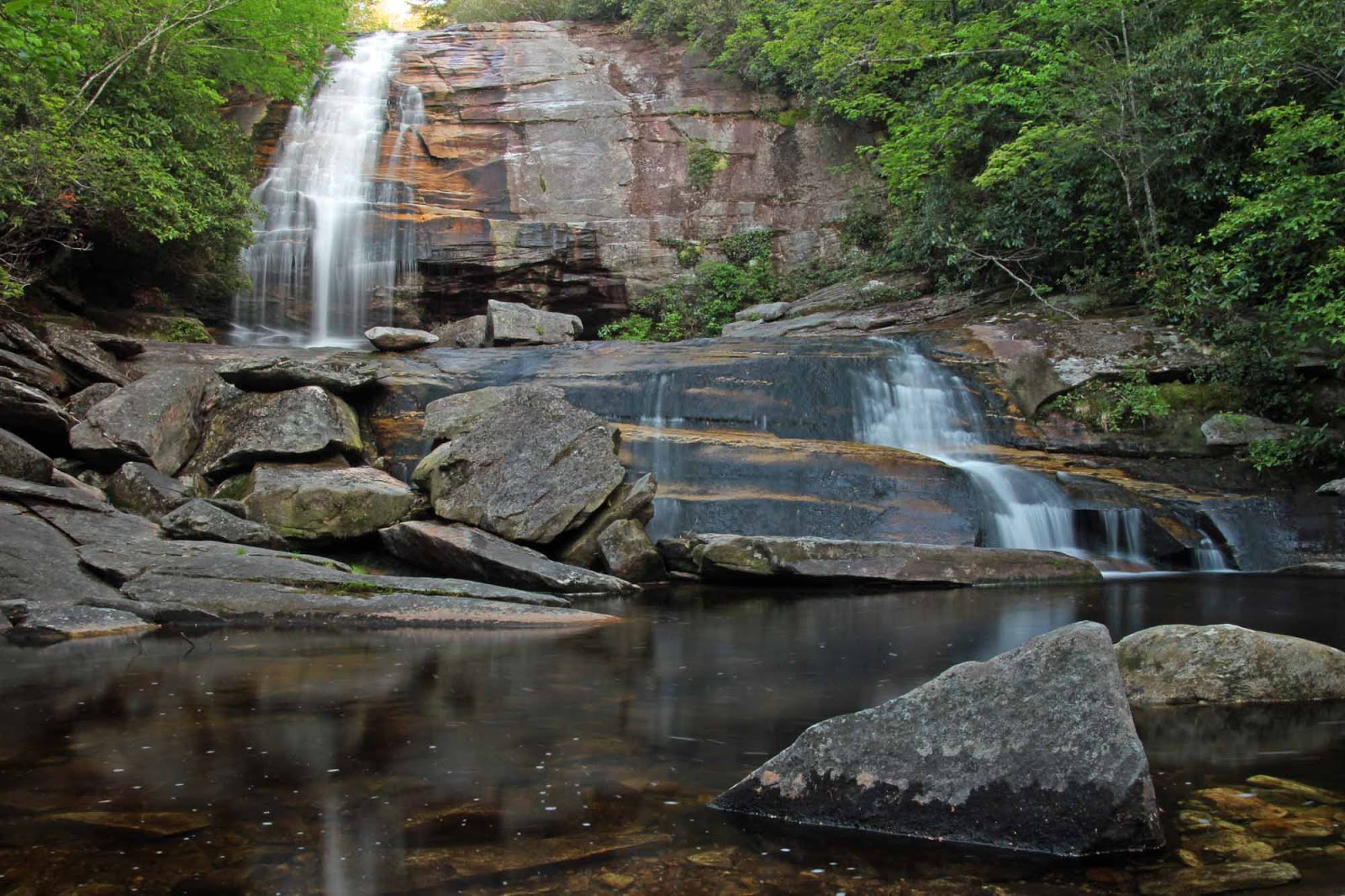
The next part of our journey would be a river walk through the Mighty Tuck stopping at one of the prettiest waterfalls in the Panthertown Valley.  Lichen Falls!

 Me, Darrin, Josh, Stan
and Wally
at Lichen Falls


We continued our river walk through the Tuckasegee River for about a half mile navigating our way past a variety of obstacles including Red Butt Falls.  Darrin decided that Red Butt was definitely one that he could slide down!

 Darrin sliding down Red Butt Falls

Shortly past Red Butt, we left the river and got on an actual trail where we ran into Spencer, Stephanie, Andy, and Scott.

 
Stephanie, Spencer, and Andy

Scott decided to join up with us, while Spencer, Stephanie, and Andy were heading on down to Lichen Falls.

Our next stop was Elbow Falls

 Elbow Falls

Next up would be Jawbone Falls where we met back up with Thomas and Bob who were enjoying a nice bit of R and R.

Bob relaxing on the sandy beach by Jawbone Falls

 Jawbone Falls


Ever since Darrin "The Salmon" Hamlin first saw a photo of Jawbone Falls, he was determined to slide down this one.  So that is what he did!

Darrin "The Salmon" Hamlin sliding down Jawbone Falls

The rest of the hike back to the parking area was all on well established wide track trails.  Even though it was just about all uphill it was rather easy and uneventful compared to what we've been through all day long!


Darrin, Bob, Scott, Spencer, and Stephanie would join Andy and I at our campsite alongside Greenland Creek making for a very enjoyable evening.

 Hanging Out Around the Campfire


The next morning Bob, Darrin, and I did the short hike to Greenland Creek Falls before packing up our stuff and heading our separate ways.

 Darrin and Bob at Greenland Creek Falls


It was a very enjoyable Weekend!

The complete set of Photos is posted here:
https://www.flickr.com/photos/8146392@N05/albums/72157668264801252
 
and if you missed them, Friday's shots are posted here:
https://www.flickr.com/photos/8146392@N05/albums/72157668233919351


Tuesday, May 17, 2016

2016-05-13 Pathertown

Panthertown Valley
Nantahala National Forest
Jackson County, NC
Friday, May 13th, 2016

Me at Schoolhouse Falls


My Team Waterfall group had a big adventure planned for Saturday around Panthertown, NC.  I decided to get an early start to the weekend and took a vacation day on Friday.

After setting up camp at a nice spot along Greenland Creek I hit the trails for a bit of solo dayhiking.

Here are some of the highlights:


The Great Wall of Panthertown

 Looking up from the base of the Great Wall

 Granny Burrell Falls

 Granny Burrell Falls


Big Green Mountain

 Taking a break after the strenuous climb up the north side of Big Green Mountain


Little Green Mountain
Rhododendron Bloom on Little Green Mountain

Mountain Biker on Little Green Mountain


Schoolhouse Falls

Schoolhouse Falls

Rhododendron Bloom at Schoolhouse Falls

 Schoolhouse Falls


After my buddy Andy arrived we did the short hike from our campsite to Greenland Creek Falls.

Geenland Creek Falls

 Greenland Creek Falls

 Greenland Creek Falls

Andy photographing Greenland Creek Falls

 Greenland Creek Falls


After visiting Greenland Creek Falls, we got the campfire going and enjoyed a nice relaxing evening around the campfire with absolutely no rain and perfect camping temperatures!

 Andy and me hanging out around the campfire


This was a great start to what would prove to be an awesome weekend!

The complete set of photos from Friday is posted here:


Monday, May 9, 2016

2016-05-06 Hog Wild Persistence

Hog Wild Persistence
The Waterfalls on Wild Hog Creek
and the Discovery of Persistence Falls
with Brenda and Mark
Rocky Bottom, SC
Friday, May 7th, 2016

 
Me, Brenda, and Mark by a Waterfall on Wild Hog Creek


The waterfall gurus, Bernie Boyer and Waterfall Rich Stevenson first posted about Wild Hog Creek back in 2010.  I kind of forgot about it until Andy and Brenda made a visit about a year ago.  Since then, it has been back on my Radar.

So I decided to take Friday off from work and join Brenda and Mark on an exploration of Wild Hog Creek!

Note:  This trip is entirely off trail and should only be attempted by people with significant off trail bushwhacking and navigational experience!

There is a maze of old logging roads that traverse the area, but most of these are so overgrown it is easier to just bushwhack and/or creek walk via the path of least resistance. 

Mountain Laurel Blooms

If you head directly up the creek from US178, you will be trespassing across a small section of private property.   We parked and took a route that kept us entirely on SC WMA (South Carolina Wildlife Management Area) Game Lands, eventually working our way back down to Wild Hog creek well upstream from the private property.

After some rather difficult bushwhacking through Poison Ivy, Poison Oak, Briers, and thickets of Rhododendron and Laurel we arrived at the first waterfall on Wild Hog Creek!

Waterfall on Wild Hog Creek.
Mark is in the photo for a good sense of scale

The journey upstream from here became even more of a challenge, but eventually we made it to this nice little cascade which is about 10 feet tall.


You really have to be a dedicated waterfall enthusiast to continue on from here, but the next one is a beauty!  A rope is highly recommended to get down to the base!

Mark descending down to the base of a waterfall on Wild Hog Creek


Mark and Brenda by a Waterfall on Wild Hog Creek

This one also has a very cool cave!  If you decide to make the difficult journey to see it, please tread lightly!  This is a very fragile environment!  Do whatever you can to avoid trampling the vegetation and minimize any impact from your visit!

Mark, Brenda, and Me inside the Cave

Jack-in-the-Pulpit

From inside the cave behind the waterfall

We backtracked a little and then continued our bushwhack upstream.  Brenda soon decided that she could go no more, but Mark and I continued on a short but very difficult distance.  We found one more drop of about 12 feet that definitely was not worth the effort to get to.

 One more drop along Wild Hog Creek

We decided to turn back at this point!  There might be more further upstream, and we might decide to come back and push on a little further!  However, I will save that for a winter time hike, when the forest is a bit more open and it is much more comfortable to stay in long sleeves and pants.


Less than a half mile south of Wild Hog Creek is another tributary (un-nammed) of Eastatoe Creek that we were eager to explore.  We backtracked downstream to below the first waterfall and managed to find an old logging road that was heading in the direction we wanted to go.

This was by far the easiest portion of our hike.  However that did not last long!  The road took us right next the creek we wanted to explore, except we were well above the banks.  So we proceeded to make the steep scramble down to the creek.

The small creek was basically just a long continuous slide.  Between the slick rocky surface and the thick vegetation, this was not easy going, but we persisted on!

 Mark making his way up the creek

I was becoming less and less optimistic the further we went.  Brenda took a few bad spills on the slick rocks and decided to hang back   I could see two large logs fallen across the creek and declared that if we get to the second log and don't see anything, we would turn back!

Bluets

Getting to that second log was no easy task, but the persistence paid off!  Standing on the second log we could see significant falling water up ahead and made the final push to what we are calling Persistence Falls!

Me at Persistence Falls

Fortunately Brenda was close enough that we were able to yell and encourage her to push on!  She elected to Bushwhack alongside the creek for the final stretch, but eventually did make it about 10 minutes behind Mark and Me.


 Brenda at Persistence Falls

 Persistence Falls

Brenda, Mark, and Me at Persistence Falls


It is quite possible that there is more upstream, but at this point we were satisfied with what we had found and didn't have the energy or motivation to continue on any further!  It was a great day of Waterfall Wandering.

Here are a few other miscellaneous photos from our hike.

Ferns

  
Cracked Wood

 Mark on a Huge Downed Tree

Brenda and Mark by a huge downed tree

Creepy Crawley

And this was how I elected to end the day!

A fitting end to a day exploring Wild Hog Creek

The complete set of photos is posted here:
 https://www.flickr.com/photos/8146392@N05/albums/72157667436577550

Meet Zoey

 Meet Zoey! Amy and I just adopted this beautiful girl!