Monday, September 30, 2019

2019-09-11 Washington State - Day 4 - Hidden Lake

Washington State Trip - Day 4
Mount Baker National Forest and
North Cascades National Park
Hidden Lake Trail
Wednesday, September 11th, 2019


Hidden Lake - North Cascades National Park


For my final full day of hiking, I decided to return to the North Cascades and hike the Hidden Lake Trail!   

Roadside view along the drive to the trailhead
 
 The Hidden Lake Trailhead

The Hidden Lake Trail starts out in the Mount Baker National Forest and enters the North Cascades National Park near Hidden Lake.   It starts out following the East Fork of Sibley Creek gaining elevation the entire way.  The first mile is mostly thick forest before entering a beautiful valley where the views start opening up!


View from the Hidden Lake Trail

Along the Hidden Lake Trail

view from the Hidden Lake Trail

Eventually the views mostly disappeared as I entered into some thick fog for much of the hike.  I can imagine there are some really spectacular views on a clear day.  Fortunately I love hiking in the fog, so I was not disappointed!


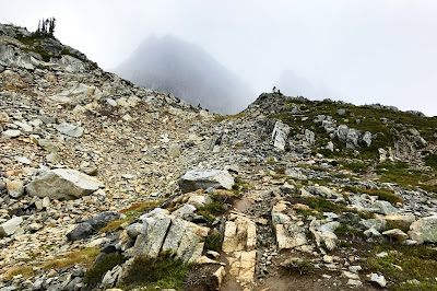
 Heading into the Fog along the Hidden Lake Trail

Heading up the Hidden Lake Trail


 View from the Hidden Lake Trail  

 Above the Clouds Selfie on the Hidden Lake Trail


 A few lingering patches of snow along the Hidden Lake Trail


Big Birds along the Hidden Lake Trail 
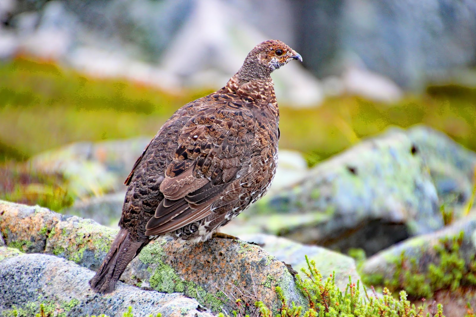
(I believe a type of Ptarmigan ???) 


Almost to the top!
(the high point of my hike is straight ahead)


 Entering the North Cascades National Park

Hidden Lake 

Hidden Lake

Just enough of an opening in the clouds to see some impressive peaks and glaciers!


The Hidden Lake Lookout Tower

Inside the Hidden Lake Lookout Tower

The Hidden Lake Lookout Tower

Hidden Lake
For a sense of scale there are two humans near the bottom of the photo

Looking back up at the Hidden Lake Lookout Tower
(near the Upper Left of Photo)

view from the Hidden Lake Trail during the hike back down


I loved every bit of this hike!  If I ever get a chance to return to the area, this one will be on my list of hikes to do again during a clearer day!  

The total hike distance was about 9.0 miles (approx. 4.5 miles out and back) with an elevation gain of about 3,700 feet.  Here is the GPS track from my hike.


 Later that evening after the drive back to Anacortes and a nice Dinner I headed up to Cap Sante Park for Sunset.  It was far from the prettiest sunset I have seen from this spot, but it was my first time this week that Mount Baker was visable!

View of Mount Baker from Cap Sante Park, Anacortes, WA

Sunset over Anacortes from Cap Sante Park
 
view from Cap Sante Park

 The Anacortes Marina at night


My complete set of photos from Day 4 is posted here:


Tuesday, September 24, 2019

2019-09-10 Washington State - Day 3 - Thornton Lakes and Trappers Peak

Washington State Trip - Day3
North Cascades National Park
Thornton Lakes Trail and Trappers Peak
Tuesday, September 10th, 2019

View from Trappers Peak

I decided to head back into the North Cascades and hike the Thornton Lakes / Trappers Peak Trail.  The trailhead is about a 2 hour drive from where we were staying in Anacortes.  The parking area was empty when I arrived at around 7:30am and I was likely the only human within many miles for the majority of my hike!

 North Cascades National Park, Washington State USA

 Thornton Lakes / Trappers Peak Trailhead

The Thornton Lakes Trail starts with a long but gradual climb of about 2,500 feet in elevation over the first 4 miles.  It is heavily forested and follows a well maintained wide track forest road along Thornton Creek.  

Once the trail turns up and away from the creek, the it narrows to a single track trail and the grade gets a bit steeper.  However, your efforts are soon rewarded as the views start to open up a bit  (unless you are hiking in the fog).

  First view of the day from the Thornton Lakes Trail

At the junction to the Trappers Peak Trail, I decided to visit Lower Thornton Lake first, so I continued on the Thornton Lakes trail down to the Thornton Lake Campsite.  In addition to the foggy lake views, I saw two Bears (or possibly the same Bear on two separate occasions) along this section of the Thornton Lakes Trail.

 Along the Thornton Lakes Trail 
(I called this spot Bear Rock)

One of Two Bear Sightings along the Thornton Lakes Trail

 view of Lower Thornton Lake

 Lower Thornton Lake

 Lower Thornton Lake

 Lower Thornton Lake


After exploring around Lower Thornton Lake, I backtracked a bit and then continued up the Trappers Peak Trail.   From Lower Thornton Lake to the Summit of Trappers peak is another 1,500 feet of elevation gain over about 1.5 miles. This is a really cool stretch of trail in the Fog!  I can only imagine what the views would be like on a clear day!

 The sun trying to make an appearance.  It never really succeeded!


 Heading up Trappers Peak

Heading up Trappers Peak
I Love this type of Trail!

Heading up Trappers Peak
It actually started snowing at this point

At the Summit of Trappers Peak

Wow!  What an amazing summit!  I loved this place in the fog, but if I ever make it back out this way, I would relish the opportunity to do this hike again on a clear day!  Until then, here are some foggy views from Trappers Peak!
View from Trappers Peak
Check out this Rock Wall!

 At the Summit of Trappers Peak

 view from Trappers Peak

 view from Trappers Peak


I had Trappers Peak all to myself except for dozens of these strange birds that inhabit the mountain!
Not sure what kind of bird this is, but they were all over Trapper's Peak!

 Big Bird on Trappers Peak

  Big Bird on Trappers Peak

  Big Bird on Trappers Peak

I was not the only one getting wet!
 Big Bird on Trappers Peak


Here are some views of Thronton Lakes from the hike back down.  It never did clear up enough for me to see and photograph all (3) of the Thornton Lakes.

In the upper right corner you can see just a little bit of Upper Thornton lake


 Lower Thornton Lake

Lower Thornton Lake

On the hike back down
Looking back up at Trappers Peak  (upper left corner)


The return hike was almost all downhill and rather uneventful except for about 1.5 hours of pouring down rain!  I ran into the only other two other humans of the day about a half mile from the trailhead.

Overall, I the hike is about 12 miles with a little over 4,000 feet of elevation gain.  I experienced rain, sleet, snow, hail, and fog.  This hike is on the top of my list of return visits for a clear day!      

Here is the GPS Track from my hike:


My complete set of photos is posted here:
https://www.flickr.com/photos/8146392@N05/albums/72157711042970277


Meet Zoey

 Meet Zoey! Amy and I just adopted this beautiful girl!