Cullowhee Area Waterfalls
Bearwallow Falls, Sugar Creek Falls, Gina Falls
Jackson County, NC
with Brenda, Mark, and Dan
Friday, June 30th, 2017
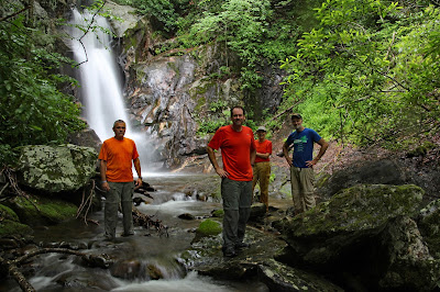
Group Photo at Bearwallow Falls
L to R: Mark, Me, Brenda, Dan
I decided to take a day off from work to join Brenda, Mark, and Dan on a waterfall adventure. Earlier this year, Brenda and Mark failed in their attempt to get to Bearwallow Falls near Cullowhee, NC. Our primary and first goal for the day would be to reach the main drop of Bearwallow Falls
Based on the weather forecast, I was fairly certain it would be a rainy day. And I did come prepared for hiking in the rain! However, I did not come adequately prepared for photography in the rain. Most of my photos from the day have water drops and water smudge marks.
The waterfalls we visited today can all be found on pages 372 through 379 of Kevin Adam's "North Carolina Waterfalls" Book (Third Edition). Therefore I am not going to repeat the directions here.
Bearwallow Falls is located off trail about a half mile bushwhack from the road. We reached the creak a bit further downstream than planned at the confluence of Bearwallow Creek and Piney Mountain Creek.
The Confluence of Bearwallow Creek and Piney Mountain Creek
With higher than normal flow, and all the rocks being wet from all the rain we didn't feel comfortable creek walking, so we headed back into the forest to bushwhack upstream. Eventually we made it to the Base of Bearwallow Falls!
Bearwallow Falls
Group Photo at Bearwallow Falls
Bearwallow Falls
From there we planned to bushwhack over to Piney Mountain Falls, but we could not find a good route so we continued downstream on Bearwallow Creek to a few other nice drops.
The next drop downstream from Bearwallow Falls
Downstream from Bearwallow Falls
It was pouring down rain now which made the rocks very slick. Mark had made it to Piney Mountain Falls on a previous trip and was not very impressed, so we decided it wasn't worth trying to continue in these conditions. Instead we elected to head over to Sugar Creek Falls which is more of a trail hike.
Sugar Creek Falls is a short and easy hike of about a half mile (1.0 mile round trip). There is a creek crossing which could probably be rock hopped on most days, but not when the water is up like it was today. So I would end up saturating my second pair of hiking boots on the day!
Sugar Creek Falls
There is also another waterfall on Dryland Laurel Branch which feeds into Sugar Creek. This one had some nice Rhododendrons blooming along side, but the rain and the wind made it impossible to get the shot I wanted.
Waterfall on Dryland Laurel Branch
For our final waterfall we decided to do a longer hike of about 5.0 miles (2.5 miles out and back) to Gina Falls outside of Sylva, NC.
What we failed to realize is that along with the 2.5 miles came almost 1,500 feet of elevation gain. About halfway up, Brenda had run out of gas. So she and Dan decided to turn back while Mark and I continued on. On top of the 1,500 feet of elevation gain, there is also a short but difficult bushwhack at the end to get to this seldom visited waterfall!
Gina Falls
Mark at Gina Falls
Gina Falls
After Gina Falls, we considered continuing on up the trail to The Pinnacle. But instead our cravings for some frosty adult beverages won out. We ended up heading back and ending our day at Kevin Adam's favorite Brewery. Mark and I made our first visit to the Boonjum Brewery tasting room in Waynesville for a flight at an appetizer! Boonjum is a highly recommend after hike stop if you are in the Waynesville, NC area!
Despite the virtually non-stop rain, it was still a great day of waterfall wandering. Much better than a day at the office!
As stated earlier, it was a huge challenge keeping the rain drops off the camera lens. So out of about 150 photos, only 15 made my final cut. They are posted here:
https://www.flickr.com/photos/8146392@N05/albums/72157685823242175


No comments:
Post a Comment