

Saturday, February 19, 2011
Sign of Spring
The first Daffodil bloomed in our yard today. Not to mention the 70 degree temperatures! Spring is upon us!


Friday, February 18, 2011
Cute Little Austin Martin
Last night we hosted another Poker Night. My buddy Jeff's wife Lori and son Austin came along to keep my wife Amy entertained. Here are a few shots from last night of Little Austin:


Yummy Ice Cream!
Wednesday, February 16, 2011
Little Hump and Big Yellow Mountain
Appalachian Trail
Avery County, NC
Sunday, February 13th, 2011
Photos are posted here:
http://outdoors.webshots.com/album/579773990ZbkLSC
A 2.5 hour drive (one way) means 5 hours of travelling! That’s a bit more than I normally like to do for a dayhike. However, Andy convinced me that this hike would be worth it. And the weather forecast made it the perfect day to visit some of the highest peaks along the Appalachian Trail.
I met Andy and Brenda in Marion, NC and we combined into one vehicle (Brenda's Xterra) from there. From Marion we took US221 to NC194 to US19E. About halfway between the Metropolises of Plumtree and Minneapolis, NC we turned left on Roaring Fork Road and headed up the mountain.
The higher we climbed, the more snow we saw. The paved portion of the road was mostly clear, but once the road turned to dirt, we would have been hard pressed to continue on without 4x4 and high ground clearance. Snow drifts over 2-feet deep remained in the shady areas.

We parked at the end of the road (just before the gate) and hit the trail. We started out hiking the Overmountain Victory Trail, a short spur trail that would connect us to the Appalachian Trail at Yellow Mountain Gap.
We took the AT to the east which climbs steeply to Little Hump Mountain. Most of the trail was covered by over a foot of snow which made for a much slower than normal hiking pace. Not to mention all the views which caused us to stop a pull out the cameras every few hundred feet!

Even though we were trekking through snow, we started shedding clothing. Andy and I were quickly down to just a t-shirt and were considering removing the legs from our zip-off pants.
That was until we left the tree sheltered area of the trail and entered the wide open exposed summit of Little Hump Mountain.

The open faced summit of Little Hump Mountain offers up 360-degree views. However it does not give any protection from the fierce and cold wind which was blowing some 50mph+ gusts! We quickly started layering up again.
Fortunately, just below the summit is an area with some huge boulders which blocked the worst of the wind and made for a nice spot to break for lunch.

Our original plan was to continue on to Big Hump Mountain, but as the trail crossed the summit and headed into the trees on the North side of Little hump the snow was even deeper than what we had been through. Instead we decided to head to Big Yellow Mountain!
Again, once leaving the bald areas and entering into the trees, the snow cover became deep. Most of the time it seemed like only about 6-inches as there was a hard frozen layer a few inches below the surface. However, every so often, our feet would break through the frozen layer and our legs would plunge into about 2-feet of snow.

The summit of Big Yellow Mountain is a huge expanse of open area. The wind seemed to have gotten even more intense. On two separate occasions, my hat was blown off my head and almost got swept over the side of the mountain never to be seen again!
The views from Big Yellow are spectacular and we spent a good bit of time roaming around taking photographs. We hadn't seen another soul all day, but we did run across a group of (3) people on Big Yellow.

On the hike back down we ran across another group of (5) people and then a stray dog that kept us company for the remainder of the hike and gave Boone a friend to play with.

We made a short detour to check out the "Red Barn" Appalachian Trail shelter before returning to Brenda's vehicle.
Andy was right! This was a great hike! The weather was perfect and the scenery was spectacular. Also, it was a pleasure to meet up with Brenda for the first time!
Overall, we hiked about 8-miles, but it seemed longer as much of the hike was through deep snow! This is definitely an area I plan on getting back to!
Here is our estimated hike route and elevation/mileage profile:


My full set of photos is posted here:
http://outdoors.webshots.com/album/579773990ZbkLSC
Appalachian Trail
Avery County, NC
Sunday, February 13th, 2011
Photos are posted here:
http://outdoors.webshots.com/album/579773990ZbkLSC
A 2.5 hour drive (one way) means 5 hours of travelling! That’s a bit more than I normally like to do for a dayhike. However, Andy convinced me that this hike would be worth it. And the weather forecast made it the perfect day to visit some of the highest peaks along the Appalachian Trail.
I met Andy and Brenda in Marion, NC and we combined into one vehicle (Brenda's Xterra) from there. From Marion we took US221 to NC194 to US19E. About halfway between the Metropolises of Plumtree and Minneapolis, NC we turned left on Roaring Fork Road and headed up the mountain.
The higher we climbed, the more snow we saw. The paved portion of the road was mostly clear, but once the road turned to dirt, we would have been hard pressed to continue on without 4x4 and high ground clearance. Snow drifts over 2-feet deep remained in the shady areas.

Driving to the trailhead along Roaring Fork Road
We parked at the end of the road (just before the gate) and hit the trail. We started out hiking the Overmountain Victory Trail, a short spur trail that would connect us to the Appalachian Trail at Yellow Mountain Gap.
We took the AT to the east which climbs steeply to Little Hump Mountain. Most of the trail was covered by over a foot of snow which made for a much slower than normal hiking pace. Not to mention all the views which caused us to stop a pull out the cameras every few hundred feet!

View from the Appalachian Trail
Even though we were trekking through snow, we started shedding clothing. Andy and I were quickly down to just a t-shirt and were considering removing the legs from our zip-off pants.
That was until we left the tree sheltered area of the trail and entered the wide open exposed summit of Little Hump Mountain.

Hiking up towards the Summit of Little Hump Mountain
The open faced summit of Little Hump Mountain offers up 360-degree views. However it does not give any protection from the fierce and cold wind which was blowing some 50mph+ gusts! We quickly started layering up again.
Fortunately, just below the summit is an area with some huge boulders which blocked the worst of the wind and made for a nice spot to break for lunch.

Me at the Summit of Little Hump Mountain
Our original plan was to continue on to Big Hump Mountain, but as the trail crossed the summit and headed into the trees on the North side of Little hump the snow was even deeper than what we had been through. Instead we decided to head to Big Yellow Mountain!
Again, once leaving the bald areas and entering into the trees, the snow cover became deep. Most of the time it seemed like only about 6-inches as there was a hard frozen layer a few inches below the surface. However, every so often, our feet would break through the frozen layer and our legs would plunge into about 2-feet of snow.

Boone and Brenda hiking through the snow
The summit of Big Yellow Mountain is a huge expanse of open area. The wind seemed to have gotten even more intense. On two separate occasions, my hat was blown off my head and almost got swept over the side of the mountain never to be seen again!
The views from Big Yellow are spectacular and we spent a good bit of time roaming around taking photographs. We hadn't seen another soul all day, but we did run across a group of (3) people on Big Yellow.

Andy, Brenda, and Boone on Big Yellow Mountain
On the hike back down we ran across another group of (5) people and then a stray dog that kept us company for the remainder of the hike and gave Boone a friend to play with.

Boone meets a new friend
We made a short detour to check out the "Red Barn" Appalachian Trail shelter before returning to Brenda's vehicle.
Andy was right! This was a great hike! The weather was perfect and the scenery was spectacular. Also, it was a pleasure to meet up with Brenda for the first time!
Overall, we hiked about 8-miles, but it seemed longer as much of the hike was through deep snow! This is definitely an area I plan on getting back to!
Here is our estimated hike route and elevation/mileage profile:


My full set of photos is posted here:
http://outdoors.webshots.com/album/579773990ZbkLSC
Tuesday, February 15, 2011
The Best of Boone
Sunday, February 13th, 2011
I am almost finished going through all the photos from Sunday's hike. Somehow I managed to take over 100 photos of Andy's Dog Boone. I'll get the trip report and full set of photos posted tomorrow, but for now here is The Best of Boone!


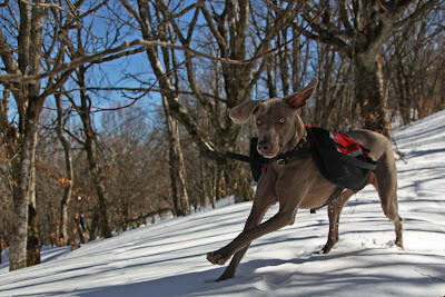


I am almost finished going through all the photos from Sunday's hike. Somehow I managed to take over 100 photos of Andy's Dog Boone. I'll get the trip report and full set of photos posted tomorrow, but for now here is The Best of Boone!


Monday, February 14, 2011
Lake Jocassee Dam Power Line Hike
Pickens County, SC
Saturday, February 12th, 2011
Photos are posted here:
http://outdoors.webshots.com/album/579765834djsWyK
The Upstate Hiking and Outdoor Adventure group is a very active hiking club.
http://www.meetup.com/upstate-hiking-and-outdoor-adventures/
They usually end up with a pretty good turnout on most of their hikes. I generally prefer hiking with smaller groups (2-4 people) and therefore I do not sign up for many of these hikes. However, this past Saturday I saw a hike that intrigued me and I signed up.
It was an "exploratory" hike, meaning that none of the group has done it before. We would be exploring an area around the Dam between Lake Jocassee and Lake Keowee.
I was running a little early as usual, so before meeting the group I made a quick stop at the Table Rock Visitors Center where I picked up a nice map of the Lake Jocassee area. Also, with the morning still, the small lake at the visitor's center had a mirror like reflection, making for an excellent photo opportunity.

The group (9 of us) met up at the intersection of Hwy11 and US178 and caravanned from there. We parked along the shoulder of Roy Jones Hwy just before the gated entrance to "The Cliffs at Keowee Vineyards" development and started our hike.
Most of the hike would be on Duke Power property and follow a power line clearing towards the Lake Jocassee Dam. A wide network of trails and maintenance roads criss-cross the area. Some of the trails actually had signs establishing names like Janet's Hill, Bear Tree Trail, and Buck Hollow Trail. We were pretty much just following the power lines taking whichever trails we thought would take us in the right direction.

While we didn't pass any no trespassing signs, we definitely ended up on "The Cliffs" property at one point. They don't take kindly to outsiders, so we quickly made our way back into Duke Power and SCDNR lands.
We eventually found out that you can't actually hike to the Jocassee Dam as the road leading in that direction is gated and heavily posted with no trespassing signs. Instead we elected to head north. The dirt road we were hiking travels alongside Lake Jocassee and there were plenty of wintertime "through the trees" views, but no wide open vistas.

The only wide open (non power line) view was actually towards the East (away from the lake) which is where we decided to turn around and head back.

For the most part, we returned back the way we came, except for a short section of bushwhacking to avoid crossing over onto "The Cliffs" property. I would estimate that we hiked a total of about 10-12 miles.

The weather was absolutely beautiful with bright sunny skies and unseasonably warm temperatures. It was great to see some old friends and meet a few new ones!
Although this is not a hike that I would recommend or plan on doing again, it was still very interesting and enjoyable. And there are loads of other trails in the area still waiting to be explored!
My full set of photos is posted here:
http://outdoors.webshots.com/album/579765834djsWyK
Pickens County, SC
Saturday, February 12th, 2011
Photos are posted here:
http://outdoors.webshots.com/album/579765834djsWyK
The Upstate Hiking and Outdoor Adventure group is a very active hiking club.
http://www.meetup.com/upstate-hiking-and-outdoor-adventures/
They usually end up with a pretty good turnout on most of their hikes. I generally prefer hiking with smaller groups (2-4 people) and therefore I do not sign up for many of these hikes. However, this past Saturday I saw a hike that intrigued me and I signed up.
It was an "exploratory" hike, meaning that none of the group has done it before. We would be exploring an area around the Dam between Lake Jocassee and Lake Keowee.
I was running a little early as usual, so before meeting the group I made a quick stop at the Table Rock Visitors Center where I picked up a nice map of the Lake Jocassee area. Also, with the morning still, the small lake at the visitor's center had a mirror like reflection, making for an excellent photo opportunity.

Table Rock Visitors Center
The group (9 of us) met up at the intersection of Hwy11 and US178 and caravanned from there. We parked along the shoulder of Roy Jones Hwy just before the gated entrance to "The Cliffs at Keowee Vineyards" development and started our hike.
Most of the hike would be on Duke Power property and follow a power line clearing towards the Lake Jocassee Dam. A wide network of trails and maintenance roads criss-cross the area. Some of the trails actually had signs establishing names like Janet's Hill, Bear Tree Trail, and Buck Hollow Trail. We were pretty much just following the power lines taking whichever trails we thought would take us in the right direction.

Hiking along the Power Line Trails
While we didn't pass any no trespassing signs, we definitely ended up on "The Cliffs" property at one point. They don't take kindly to outsiders, so we quickly made our way back into Duke Power and SCDNR lands.
We eventually found out that you can't actually hike to the Jocassee Dam as the road leading in that direction is gated and heavily posted with no trespassing signs. Instead we elected to head north. The dirt road we were hiking travels alongside Lake Jocassee and there were plenty of wintertime "through the trees" views, but no wide open vistas.

Through the trees view of Lake Jocassee
The only wide open (non power line) view was actually towards the East (away from the lake) which is where we decided to turn around and head back.

View from 'Horsepasture Road'
For the most part, we returned back the way we came, except for a short section of bushwhacking to avoid crossing over onto "The Cliffs" property. I would estimate that we hiked a total of about 10-12 miles.

My best guess as to the hike route (not from a GPS - this based on my memory and looking at Goggle Earth)
The weather was absolutely beautiful with bright sunny skies and unseasonably warm temperatures. It was great to see some old friends and meet a few new ones!
Although this is not a hike that I would recommend or plan on doing again, it was still very interesting and enjoyable. And there are loads of other trails in the area still waiting to be explored!
My full set of photos is posted here:
http://outdoors.webshots.com/album/579765834djsWyK
Sunday, February 13, 2011
Wow! Great Hike Today!
Here are a few shots. It will take me a few days to go through them all!


Boone

Break Time

Iggy

King of the Mountain
Saturday, February 12, 2011


Subscribe to:
Posts (Atom)

-
 Pilot Mountain Shuttle Hike and Laurel Fork Falls Pisgah National Forest, NC Friday, April 3rd, 2015 Since Good Friday is a holiday f...
 -
 Polebridge, Bowman Lake, Lower Quartz Lake Glacier National Park, Montana Friday, September 2nd, 2011 For our last day at Glacier National ...
 -
 Pisgah National Forest, Grandfather Ranger District Burke County, NC Saturday, August 28th, 2010 Photos are posted here: http://outdo...