
Burke County, NC
Sunday, March 13th, 2011
Photos are posted here:
http://outdoors.webshots.com/album/579908065tCavMG
The Linville Gorge Wilderness Area is known for having some of the most rugged terrain in the Eastern United States. However, smack in the middle of this ruggedness is a relatively flat area where thousands of Daffodils bloom every March.
Before the Gorge was declared a wilderness area, a few homesteads existed along the Linville River. In front the Dellinger house was a small garden of Daffodils. The house and any roads leading to it are long gone, but those Daffodils still thrive and multiply every year!

Daffodil Flats
Andy and I have been using this field of Daffodils as an excuse to make an annual March pilgrimage into the Linville Gorge. There are several routes you can take to get to Daffodil Flats, but none of them are easy. This year, we planned an even longer and tougher hike than usual.
We parked Andy's car at near the southern end of Kistler Memorial Highway at the start of Wolfpit West Road. Since we decided on doing a one-way shuttle hike, we combined into my truck and drove approximately 9.0 miles to the Old Conley Cove Trailhead (a small pull-off just south of the New Conley Cove Trailhead).
We got a nice early start and hit the trail at around 8:45am starting at the northern end of the Rock Jock Trail. With all the side trails and awesome scenery, one could easily spend a full day hiking and exploring this trail. It is always a challenge to keep moving on the Rock Jock as amazing views offer endless reasons to stop.

View from Hackers Point on the Rock Jock Trail
Along the Rock Jock, we pretty much stuck to the trail with only one exception! Razors Edge! This would be my fourth time hiking the Rock Jock since its revival several years ago and I have never been to Razors Edge. Somehow, we always seem to miss the side trail! This time, we were determined to find it!
To be honest, I don't know how the heck we missed it on previous hikes. It’s a very obvious side trail with ribbons on the trees both before and after the junction, and a cairn of rocks in the middle of the main trail. Basically the Razors Edge Side Trail junction was about as obvious as a hand grenade in a bowl of oatmeal!
The view from Razors edge definitely did not disappoint, but we didn't linger as we still had a long day ahead of us!

view from Razors Edge
Over the last few weeks, the area has finally received a series of drought busting rains! There are about 6 or 7 low flow streams and waterfalls that traverse the Rock Jock Trail and these were all flowing better than I have ever seen them! Usually they are all just a series of non-photo worthy trickles, but some of these cascading streams had me regretting that I decided not to lug around the tri-pod!

Blue Jay Falls - Rock Jock Trail
Any regrets about not having the tri-pod turned out to be forgotten later in the day as those extra water bottles I took instead proved to be much more beneficial!
By 11:00, temperatures of the day were already well into the 70s! I wanted to zip-off my pant legs, but decided to wait until after the bushwhacking portion of our hike.
Our plan was to use the Pinch-in Trail to descend down into the gorge. Unfortunately about a half mile separates the southern end of Rock Jock from the Pinch-in Trail. We had two options to get around this:
1. Finish up the Rock Jock Trail which very steeply gains about 600-ft of elevation up to Kistler Highway, Walk Kistler Highway a half mile to the Pinch-in Trail only to descend back down the 600-feet we just climbed.
Or
2. Bushwhack the half mile keeping a fairly consistent elevation over to the Pinch-in Trail!
We chose option #2. But first we took our main lunch break of the day!

Andy taking a break
Back in 2007, intense forest fires scorched this part of the Linville Gorge Wilderness. As a result, this bushwhack is through a fairly open forest. Unfortunately, it seems that the first things to grow back after a forest fire are the briars! It was definitely a good decision to keep the pant legs zipped on a little while longer!
We started the bushwhack by following some flagging, but after short distance we failed to see any more ribbons. We continued on by following our instincts and the path of least resistance. It took us about 35 minutes to travel the half-mile, which for bushwhacking is a pretty good pace. Our navigation was also spot-on as we ended up on the Pinch-in Trail only about 20 yards up trail from our target point!

Andy and Boone hiking down the Pinch-in Trail
There are a lot of Gorge Rats out there that absolutely loathe the Pinch-in Trail. But I think it offers a very cool perspective of the Linville Gorge! Of course, it is much more enjoyable hiking downhill as we would be doing today. The Pinch-in Trail descends over 1,000-feet over the next half mile, before leveling out a bit as it closes in on the Linville River.

The Linville River
Next up would be about a 2-mile stretch of the Linville Gorge Trail (LGT). We were figuring that this would be the easiest part of our day, since the LGT parallels the river and stays at a fairly constant elevation. However, surprisingly abundant deadfall made the trek along the LGT a lot tougher and slower than anticipated.
Daffodil Flats came at the perfect time and offered up an excuse to take a much needed break from climbing through deadfall!

Daffodil Flats
Last years hike was a couple of weeks later and most of the blossoms were starting to droop and fade. This time we were a few days before peak bloom and there were not as many flowers out. However, the ones that were blooming were in much better condition.

Daffodil Flats
There was a stiff breeze on the day which felt delightful, but made photographing the Daffodils a bit of a challenge. Plus since we both elected not to tote the tri-pods today, we didn't put forth as much time or effort into our flower photography as past years.
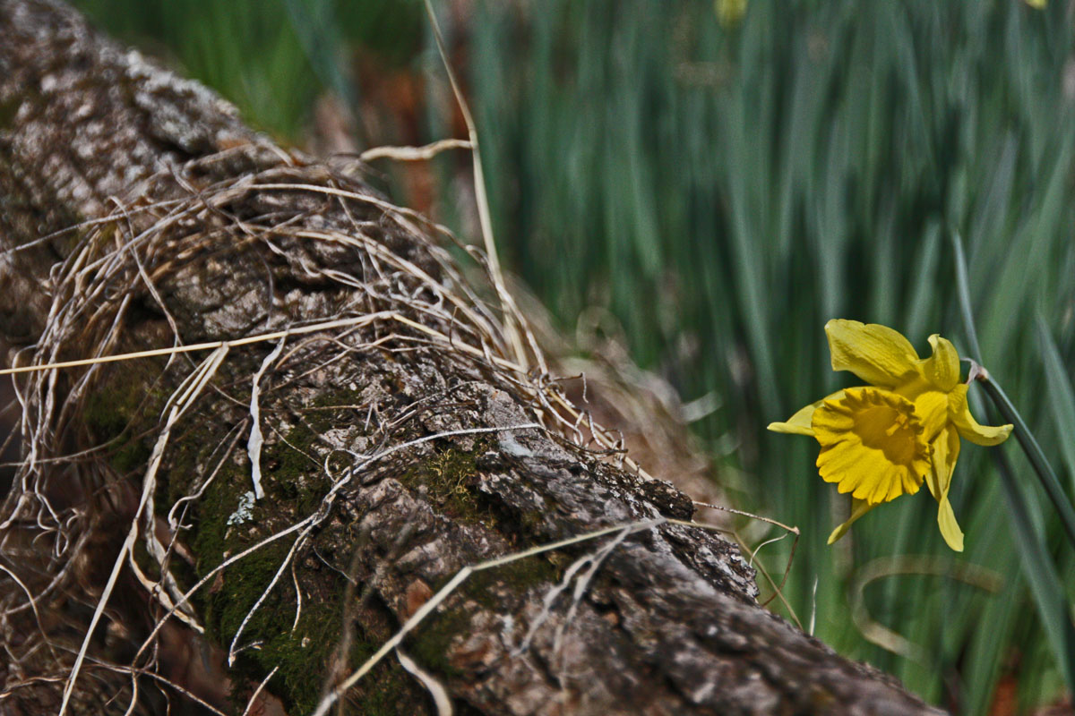
At Daffodil Flats
We hadn't seen a single other person all day until we hit the LGT. There we ran into one group of three guys camping above Blue Hole, and a large group of about eight guys and three gals camping at Dellinger Creek.
We chatted briefly with each group and after hearing horror stories from the three girls about their journey across Sharp Ridge Cliffs, we decided that our best exit strategy would be the Leadmine Trail.
Leadmine is one of those unofficial trails that you won't find on any official forest service maps. The initial section climbs up from the river at an ungodly steep angle. This part of the Leadmine trail is in serious need of a major redesign and/or re-routing! A few switchbacks sure would be nice!
Although the trail eventually levels out and appears to follow a constant elevation the remainder of the way south, it is actually about as level as a roller coaster. It travels up and down 3 or 4 steep gullies each time dropping and then gaining back about a hundred feet or so.

Inside a hollow tree along the Leadmine Trail
There was much less deadfall along Leadmine than we were expecting and parts of the trail are in really good shape. Even along the less than desirable sections of trail, it is still easy enough to follow and is an essential connector trail for completing several great hike options in the Linville Gorge.
By the time we reached the 5-way junction at the end of Leadmine we were all beat and took another short break! Our initial plan was to park Andy's vehicle at the Pinnacle Trailhead which would have meant a 1,000-ft + climb to end our hike.
Instead, we decided to try Wolf Pit West Road. This 2.5 mile Forest Service Road added about 1.5 mile to the length of our planned hiked, but it eliminated the brutal climb at the end.
A connector trail leads from the 5-way intersection to the end of Wolf Pit West Road. This short connector featured one more gully to descend down into. The short climb out of the gully made us very grateful that we changed our plans and did not have a thousand more feet to climb!
Wolf Pit West Road was very unexciting! It winds around the contour lines gradually gaining a few hundred feet of elevation. It took us a little less than an hour to hike the entire length of Wolf Pit West, but it felt much longer than that as we were all anxious to finish up the hike!

Andy at the end of Wolf Pit Road West
We spent almost 10 hours hiking the Gorge. It is now two days later my legs are still sore! However, I have no regrets! We planned an aggressive hike and everything went exactly as planned. It is great to have buddies like Andy and Boone, because I would not want to attempt a hike like this solo!
Here is our hike route:

The full set of photos is posted here:
http://outdoors.webshots.com/album/579908065tCavMG
Bonus Question: Did anyone catch the Foghorn Leghorn quote in the above trip report?


4 comments:
Holy crap! What a hike! Is Andy conditioning for a long-distance multi-day backpack?! I don't know if I could have kept up with you guys, so it's probably best I couldn't make this one. I need to get about twenty pounds off to be able to keep up the pace you set.
Absolutely Awesome hike Jack!
Next time you are on Rockjock, you might want to have a look at Crevasse creek. These little side trips take time. To do what you did , you had to be hurrying on. But the side trips off Rockjock are where the jewels are burried.
I gotta admit that the hike out via Wolfpit West road is the longest Drag-Ass hike youll ever take for only 2.5 miles. Utterly boreing. But its not bad on a Mountain Bike!.
Thanks for the journey my friend. Loved it. Looking forward to your next outing already....hahaha.
Time for an in-joke!!!
Post a Comment